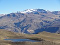
Aceruta (possibly from Aymara asiru snail, uta house, "snail" or -ta a suffix, "from the snail") is a mountain in the Andes of Peru, about 5,400 metres...
2 KB (134 words) - 00:51, 29 March 2022
of Chachas and Orcopampa. Huamangore lies northwest of Huañacagua and Aceruta. "Cerro Huamangore". IGN, Peru. Archived from the original on May 30, 2015...
2 KB (106 words) - 05:29, 15 April 2022
southwest of Huayllatarpuna and Condorcacha and northeast of Chinchón and Aceruta. escale.minedu.gob.pe - UGEL map of the Caylloma Province 1 (Arequipa Region)...
2 KB (142 words) - 05:30, 15 April 2022
south of Huanca and Sullucullahua, northeast of Chinchón and southeast of Aceruta. escale.minedu.gob.pe - UGEL map of the Caylloma Province 1 (Arequipa Region)...
1 KB (141 words) - 05:30, 15 April 2022
Province, Chachas District. Sullucullahua lies northeast of Chinchón and Aceruta and southeast of Huanca. escale.minedu.gob.pe - UGEL map of the Caylloma...
2 KB (149 words) - 01:55, 16 April 2022
Chachas District. Chinchón is situated southwest of Huayta and southeast of Aceruta. escale.minedu.gob.pe - UGEL map of the Caylloma Province 1 (Arequipa Region)...
1 KB (103 words) - 05:23, 15 April 2022
(17,930 ft) Jatunpila, 5,450 m (17,880 ft) Airicoto, 5,400 m (17,700 ft) Aceruta, 5,400 m (17,700 ft) Chinchón, 5,400 m (17,700 ft) Choquepirhua, 5,400 m...
5 KB (417 words) - 08:13, 25 December 2023
Chachas District. Huañacagua lies northwest of Chuañuma and southwest of Aceruta. escale.minedu.gob.pe - UGEL map of the Castilla Province (1) (Arequipa...
2 KB (137 words) - 05:30, 15 April 2022