
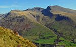
Boulsworth Hill is a large expanse of moorland, the highest point of the South Pennines of south-eastern Lancashire, England, separating the Borough of...
5 KB (367 words) - 10:26, 26 April 2024
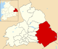
Pendle, Lancashire, England. The ward represents the area surrounding Boulsworth Hill, including the villages of Trawden, Laneshaw Bridge and Wycoller, and...
3 KB (166 words) - 22:45, 24 October 2019

Topographic prominence (redirect from Hill prominence)
One such chain in Britain would read: Billinge Hill → Winter Hill → Hail Storm Hill → Boulsworth Hill → Kinder Scout → Cross Fell → Helvellyn → Scafell...
27 KB (3,189 words) - 02:36, 7 August 2024
and 38 miles (58, 71 and 61 km), 119 degrees Boulsworth Hill, 63 miles (101 km), 135 degrees Pendle Hill, 55 miles (89 km), 138 degrees Ward's Stone,...
23 KB (2,560 words) - 12:23, 17 July 2024

slopes of Boulsworth Hill, whilst the long distance Bronte Way passes through en route to Haworth. Colne is approximately 5 miles east of Pendle Hill, arguably...
43 KB (4,791 words) - 00:38, 11 August 2024

Ingleborough (category Mountains and hills of the United Kingdom with toposcopes)
Hill, 10 miles, 132 degrees Boulsworth Hill, 27 miles, 155 degrees Kinder Scout, 58 miles, 159 degrees Shining Tor, 65 miles, 166 degrees Pendle Hill...
17 KB (2,058 words) - 06:56, 11 August 2024

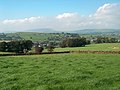
is a village in the Trawden Forest parish of Pendle, at the foot of Boulsworth Hill, in Lancashire, England. The village co-operatively owns and runs its...
6 KB (636 words) - 11:47, 9 April 2024

Salterforth Sough Trawden Wheatley Lane Winewall Wycoller Boulsworth Hill Noyna Hill Pendle Hill Weets Hill The following people and military units have received...
33 KB (1,686 words) - 20:28, 31 July 2024
called Beardshaw) and the hamlets of Cottontree, Winewall and Wycoller. Boulsworth Hill is a well known local landmark situated within the parish. It takes...
4 KB (233 words) - 10:40, 2 April 2020

of the Hameldon Hill wind farm have stood on its northern flank. To the east of the town lie the 1,677 feet (511 m) Boulsworth Hill and the moors of...
121 KB (12,065 words) - 02:13, 15 August 2024