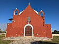
Cantamayec (In the Yucatec Maya language: Zuelania guidonia: "four tamay trees") is a municipality in the Mexican state of Yucatán containing (502.02 km2)...
8 KB (436 words) - 23:59, 23 February 2024

population. † State capital Akil was merged with Tekax in 1905-1919. Cantamayec was merged with Sotuta in 1905-1927. Dzán was merged with Ticul in 1905-1933...
38 KB (605 words) - 15:41, 16 July 2024
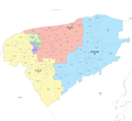
the east and south-east of the state. It comprises 27 municipalities: Cantamayec, Yaxcabá, Cuncunul, Chacsinkín, Chankom, Chemax, Chichimilá, Chikindzonot...
17 KB (1,000 words) - 02:11, 15 August 2024
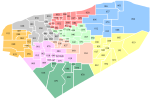
unlike the 2022 plan, excluding the coastal municipalities: Abalá, Akil, Cantamayec, Chacsinkín, Chapab, Chochola, Chumayel, Cuzamá, Dzán, Halachó, Homún...
14 KB (903 words) - 01:05, 17 August 2024
north with Mayapán-humayel, on the south with Tekax, on the east with Cantamayec-Tixméhuac and the west with Maní-Akil. It is home to indigenous Mayan...
11 KB (714 words) - 08:45, 15 August 2024