
Debelyanov Point (Bulgarian: Дебелянов нос, ‘Debelyanov Nos’ \de-be-'lya-nov 'nos\) is a point forming the northwest side of the entrance to Mitchell Cove...
2 KB (155 words) - 17:28, 8 July 2019
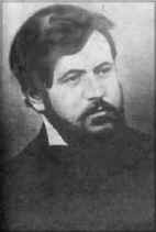
Dimcho Debelyanov (Bulgarian: Димчо Дебелянов) (28 March 1887 – 2 October 1916) was a Bulgarian poet and author. Born to a prosperous tailoring family...
5 KB (456 words) - 15:27, 28 April 2023
of Debelyanov Point and 3.35 km north by west of Negra Point. The point is named after the settlement of Divotino in western Bulgaria. Divotino Point is...
2 KB (172 words) - 18:01, 8 July 2019
Onogur Islands, 3.55 km south-southwest of Hammer Point and 3.23 km north-northwest of Debelyanov Point (British mapping in 1935, 1948, 1967 and 1968, Argentine...
2 KB (202 words) - 22:24, 8 September 2022
Antarctica southeast of Alfatar Peninsula, and entered between Debelyanov Point and Negra Point. The area was visited by early 19th century sealers. The feature...
1 KB (157 words) - 19:56, 22 November 2022
Greenwich Island, 2.8 km southeast of Debelyanov Point, 4.5 km northwest of Beron Point and 8.84 km northwest of Edwards Point (Chilean mapping in 1975, British...
2 KB (191 words) - 20:15, 6 June 2021
It is bounded by Debelyanov Point to the southwest, the undulating interior of Alfatar Peninsula to the northwest and Divotino Point to the northeast...
2 KB (222 words) - 00:01, 26 November 2020

Island Debelyanov Point, Robert Island Debren Pass, Sentinel Range Delchev Peak, Livingston Island Delchev Ridge, Livingston Island Deliradev Point, Anvers...
6 KB (524 words) - 13:07, 12 November 2022
The Triplets (Robert Island) (redirect from Aconcagua Point)
William, 750 m west-northwest of Debelyanov Point, 3.55 km northwest of Negra Point, 6.22 km north-northeast of Spark Point, Greenwich Island, 3.13 km east-northeast...
2 KB (246 words) - 18:19, 3 July 2017

Island, 3.39 km (2.11 mi) southwest of Debelyanov Point, Robert Island and 4.83 km (3.00 mi) west of Negra Point, Robert Island (Chilean mapping in 1961...
4 KB (308 words) - 03:01, 29 April 2022