
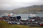
Eysturoy (Faroese pronunciation: ['ɛstroi], meaning 'East Island') is a region and the second-largest of the Faroe Islands, both in size and population...
7 KB (479 words) - 21:03, 2 October 2023

Eysturoyartunnilin (redirect from Eysturoy Tunnel)
Eysturoyartunnilin (in English The Eysturoy Tunnel, earlier known as Skálafjarðartunnilin) is a large undersea road tunnel under the Tangafjørður sound...
23 KB (2,351 words) - 15:47, 24 September 2024

Innan Glyvur is a village on the Faroese island of Eysturoy in the Sjóvar Municipality. It is on the west side of Skálafjørður. It was founded in 1884...
4 KB (59 words) - 15:16, 15 September 2023

the Faroe Islands, on Oyndarfjørður (fjord), located on the east side of Eysturoy. Hellurnar is part of the municipality of Fuglafjørður. Hellurnar was founded...
4 KB (74 words) - 15:53, 24 March 2024

them in order to keep sheep out. Streymoy is separated from the nearby Eysturoy, the second-largest island of the Faroe Islands, by the sounds of Sundini...
9 KB (816 words) - 10:42, 1 September 2023

Norðragøta (Danish: Nordregøte), also just referred to as Gøta, is a village on Eysturoy island, Faroe Islands. The municipality of Gøta (Gøtu kommuna) was a municipality...
7 KB (349 words) - 11:42, 27 February 2024
established between Norðskáli on Eysturoy and Nesvík on Streymoy; in 1976 the new tunnel between Norðskáli and Eysturoy was completed. The Faroes' two largest...
15 KB (1,558 words) - 08:56, 22 May 2024

at an elevation of 880 metres. It is located in the northern part of Eysturoy, between the villages of Eiði, Gjógv, and Funningur. Funningur lies at...
2 KB (156 words) - 15:00, 2 September 2024

coasts are mostly cliffs. The highest point is Slættaratindur in northern Eysturoy, 882 metres (2,894 ft) above sea level. The Faroe Islands are made up of...
151 KB (16,026 words) - 13:51, 3 October 2024

under the Leirvíksfjørður in the Faroe Islands. It connects the islands of Eysturoy and Borðoy. The tunnel is 6.2 km long and goes down to a depth of 150 metres...
4 KB (304 words) - 15:30, 29 September 2024