
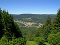
kilometres, the Großer Farmdenkopf is one of the most dominant mountains in Thuringia. Only the Großer Finsterberg (944 m), 21.3 km away, the Großer Eisenberg...
5 KB (443 words) - 00:14, 22 October 2022

Rhine-Westphalia Taunus Großer Feldberg 878.5 2,882 Hesse Teutoburg Forest Barnacken 446 1,463 North Rhine-Westphalia Thuringian Highland Großer Farmdenkopf 869 2,851...
24 KB (142 words) - 11:46, 24 June 2024

Highland Großer Farmdenkopf 869 50°30′30″N 11°02′00″E / 50.50833°N 11.03333°E / 50.50833; 11.03333 (Großer Farmdenkopf) ± 30″ Taunus Großer Feldberg...
11 KB (509 words) - 12:52, 11 September 2023
in the district of Nordhausen. Großer Ehrenberg (635.3 m), near Rothesütte Vogelheerd (634.4 m), near Rothesütte Großer Steierberg (619.5 m), near Rothesütte...
22 KB (1,702 words) - 10:34, 27 November 2023
more than 800m tall hills (the highest elevation is the 869m high Großer Farmdenkopf) down to the lower plains Sonneberger Unterland and Schalkauer Platte...
6 KB (359 words) - 19:44, 6 July 2024
as much as 300 m or more, which is large for hills of this size. Großer Farmdenkopf (869 m), Sonneberg district Kieferle (867 m), Sonneberg district Bleßberg...
7 KB (832 words) - 17:42, 6 September 2023
Elevation 867.2 m above sea level (NHN) (2,845 ft) Isolation 5.9 km → Großer Farmdenkopf Coordinates 50°28′09″N 11°05′33″E / 50.469300°N 11.092419°E / 50...
3 KB (209 words) - 01:00, 24 December 2022