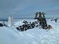
Shining Tor is the highest hill in Cheshire, England. The summit has an elevation of 559 m (1,834 ft) above sea level. It is in the Peak District, between...
4 KB (415 words) - 15:27, 20 June 2024
List of hill forts in England Shining Tor "Mam Tor (Shivering Mountain)". Peak Hideaways. Retrieved 6 April 2016. "Mam Tor". National Trust. Archived from...
10 KB (1,177 words) - 20:36, 1 June 2023

Dovedale (redirect from Pickering Tor)
Trust clears plant life to ensure the rock formations are visible. Pickering Tor Tissington Spires Dovedale Church Reynard's Cave Lionshead Rock Ilam Rock...
20 KB (2,174 words) - 05:53, 10 April 2024

that starts between Kettleshulme and Whaley Bridge and culminates at Shining Tor. The crag was featured in the first guide to rock climbing in the Peak...
2 KB (158 words) - 11:45, 16 April 2024
Tor is a free overlay network for enabling anonymous communication. Built on free and open-source software and more than seven thousand volunteer-operated...
188 KB (16,225 words) - 17:27, 14 August 2024

point is Shining Tor on the Derbyshire/Cheshire border between Macclesfield and Buxton, at 559 metres (1,834 ft) above sea level. After Shining Tor, the next...
92 KB (7,854 words) - 22:34, 1 August 2024

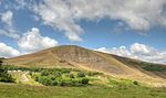
above sea level. Tor is an Old English word for a high, rocky hill. The higher peak of Shining Tor is about 2 km south along The Tors gritstone ridge....
6 KB (562 words) - 06:20, 27 September 2023

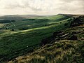
south. The western side of the valley is a long ridge, running from Shining Tor to Windgather Rocks, which forms the county boundary between Derbyshire...
8 KB (832 words) - 21:37, 30 January 2021
of which rise to over 600 m (2,000 ft)), Black Hill, the Roaches, Shining Tor, Mam Tor, Win Hill and Stanage Edge. Over the years, military aircraft have...
7 KB (656 words) - 22:20, 19 July 2024

808 ft)) is at grid reference SK035706. This is slightly lower than Shining Tor (which is some 5 kilometres (3.1 mi) to the northwest, across the modest...
2 KB (154 words) - 18:51, 15 October 2023