
Yewbarrow is a fell, in the English Lake District, which lies immediately north of the head of Wast Water. It is 628 metres (2,060 feet) high and in shape...
6 KB (660 words) - 23:26, 6 November 2023

ran clockwise to Yewbarrow (peak 31 on a clockwise Round), reversed and ran back to Keswick, then continued anticlockwise to Yewbarrow (now peak 12 on...
19 KB (2,171 words) - 12:47, 2 January 2024
the highest peak in England, which, along with Scafell, Kirk Fell and Yewbarrow, surround the small community of Wasdale Head. Wasdale is famous amongst...
6 KB (555 words) - 16:54, 10 April 2023
Whin Rigg Whinlatter White Side Whitfell Whiteless Pike Whiteside Yoke Yewbarrow These are the 214 fells selected by Alfred Wainwright for a chapter in...
23 KB (2,842 words) - 18:49, 25 May 2024
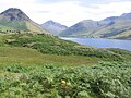
cliffs of Buckbarrow (a part of Seatallan) and the upturned-boat shape of Yewbarrow. Wast Water is the source of the River Irt which flows into the Irish...
9 KB (979 words) - 21:21, 12 September 2024

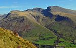
View of the Scafell massif from Yewbarrow, Wasdale, Cumbria. In the valley are older enclosures and higher up on the fell-side are the parliamentary enclosures...
14 KB (1,578 words) - 17:53, 22 September 2024
Scafell Pike Scafell Pike (centre) from Yewbarrow Highest point Elevation 978 m (3,209 ft) Prominence 912 m (2,992 ft) Ranked 13th in British Isles Parent...
23 KB (2,560 words) - 19:05, 18 August 2024

View of the Scafell massif from Yewbarrow, Wasdale, Cumbria. In the valley are older enclosures and higher up on the fell-side are the parliamentary enclosures...
60 KB (7,369 words) - 20:14, 21 August 2024

England. The eastern side of the village borders Whitbarrow Scar with Yewbarrow, which is a small limestone hill, located in the centre of the village...
5 KB (478 words) - 19:11, 11 July 2023

tributaries of the River Kent. Longsleddale Woods are designated an SSSI. Yewbarrow Woods were acquired by the Lake District National Park in the 1980s in...
10 KB (1,046 words) - 17:44, 29 September 2024