
Edward Elgar Publishing. pp. 36, 194, 203. ISBN 9781786437969. 平成14年2万5千分1地形図図式 [2002 1:25000 Topographical Map Scheme] (in Japanese). Geospatial Information...
176 KB (18,018 words) - 05:56, 5 August 2024

(November 25, 1999). Accessed January 27, 2019.") (in Japanese) 1/25000地形図の発行年・発行図歴一覧 宮古・八重山地方 国土地理院] ("List of publication years and publication history...
24 KB (2,793 words) - 04:05, 27 July 2024

etsuran sābisu 2 man 5 sen-bu 1 chikei-zu-mei: Fujisan (Kōfu)" 地図閲覧サービス 2万5千分1地形図名: 富士山(甲府) [Map viewing service 1:25,000 topographic map name: Mt. Fuji (Kofu)]...
68 KB (6,092 words) - 19:41, 12 August 2024

測量法施行令第2条第2項 国土地理院時報 (PDF). 1.1.5離島の高さ (in Japanese). 2003. p. 6. 2万5千分1地形図の読み方・使い方 (in Japanese). Kokudo Chiriin. Archived from the original on 2012-07-24...
6 KB (598 words) - 21:22, 10 January 2024

2010. 地図閲覧サービス 2万5千分1地形図名: 紋別(紋別) (in Japanese). Geospatial Information Authority of Japan. Retrieved 25 June 2010. 地図閲覧サービス 2万5千分1地形図名: 中渚滑(紋別) (in Japanese)...
10 KB (634 words) - 20:49, 22 February 2024
Kamuiwakka Hot Falls". Shari Town. Retrieved 24 March 2011. 地図閲覧サービス 2万5千分1地形図名: 知床五湖(知床岬). 25000:1 Topographical Map 知床五湖 (in Japanese). Geographical Survey...
1 KB (83 words) - 19:18, 7 February 2024
formed under low-to-mid pressure 50–20 million years ago. 地図閲覧サービス 2万5千分1地形図名: 上トマム(夕張岳). 地図閲覧サービス 2万5千分1 (in Japanese). Geographical Survey Institute...
2 KB (161 words) - 17:34, 4 July 2024

needed] List of mountains in Japan List of volcanoes in Japan 地図閲覧サービス 2万5千分1地形図名: 斜里岳(斜里). 25000:1 Topographical maps (in Japanese). Geographical Survey...
4 KB (233 words) - 18:57, 9 August 2024
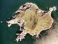
caldera. Islands portal Desert island Lists of islands 地図閲覧サービス 2万5千分1地形図名: (内挿図又は図葉外). 25,000:1 Topographical Map (in Japanese). Geographical Survey Institute...
6 KB (475 words) - 23:21, 27 April 2023

Park, Hokkaidō, Japan. It is an andesitic stratovolcano. 地図閲覧サービス 2万5千分1地形図名:白雲岳(旭川) (in Japanese). Geospatial Information Authority of Japan. Retrieved...
2 KB (79 words) - 18:01, 21 July 2024