
Kayangel (Ngcheangel) is the northernmost state of Palau 86 km (53 mi) north of Koror. The land area is about 1.4 km2 (0.54 sq mi). The population is 54...
17 KB (1,837 words) - 02:06, 7 June 2024

Flags of the states of Palau (redirect from Flag of Kayangel)
History of Hatohobei State—". Friends of Tobi. Retrieved 16 July 2021. "Kayangel, Palau". CRW Flags. Retrieved 18 July 2021. "Melekeok State Flag". Pacific...
8 KB (186 words) - 04:55, 25 June 2024

Saffir–Simpson hurricane wind scale (SSHWS); the storm passed over the island of Kayangel in Palau shortly after attaining this strength. The Philippine Atmospheric...
209 KB (16,918 words) - 13:12, 1 September 2024
About two-thirds of the population lives on Koror. The coral atoll of Kayangel is north of these islands, while the uninhabited Rock Islands (about 200)...
97 KB (7,913 words) - 10:34, 20 August 2024

Palau has over 250 islands, including: Angaur Babeldaob Caroline Islands Kayangel Ngerekebesang Island Oreor Peleliu Southwest Islands Pearl Islands List...
43 KB (4,275 words) - 13:55, 13 June 2024

population it is the country’s third smallest state (after Hatohobei and Kayangel.) The first sighting by Europeans of the Sonsorols, was that of Sonsorol...
14 KB (1,139 words) - 02:35, 4 March 2024
Operation Christmas Drop Supplies are dropped over Kayangel in Palau, 2013 Location Micronesia Objective Distribute Christmas gifts in Micronesia, train...
13 KB (1,161 words) - 12:01, 28 August 2024
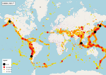
Comprehensive Catalog. U.S. Geological Survey. ANSS. "M 6.4 – 121 km ESE of Kayangel, Palau 1982". Comprehensive Catalog. U.S. Geological Survey. ANSS. "M 8...
111 KB (5,032 words) - 20:46, 31 August 2024
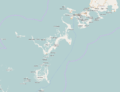
location. Northernmost point – Ngaruangel Reef, Kayangel state* Easternmost point – Kayangel islet, Kayangel state Southernmost point – Round Rock, Helen...
17 KB (1,881 words) - 09:25, 26 July 2024

at the northernmost tip of the island of Babeldaob. Only the state of Kayangel is farther north. The population of the state was 384 in the 2020 census...
10 KB (772 words) - 07:03, 14 May 2024