
45°22′58″N 36°38′43″E / 45.38278°N 36.64528°E / 45.38278; 36.64528 Cape Fonar Cape Fonar (‹See Tfd›Russian: Мыс Фонарь, Ukrainian: Мис Фонар, Crimean Tatar:...
4 KB (399 words) - 02:41, 11 October 2022
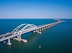
government announced preliminary preference for a route between Cape Fonar and Cape Maly Kut. Had that project been carried out, it would have meant...
96 KB (8,132 words) - 01:31, 25 August 2024

of Ukraine. Sarych Simferopol Sevastopol Kerch Isthmus of Perekop Cape Fonar Cape Priboiny Karkinit Bay Syvash Kalamita Bay Black Sea Sea of Azov Covering...
111 KB (10,361 words) - 13:19, 27 September 2024

Tfd›Russian: Еникальский маяк, Yenikal'sky mayak) is an active lighthouse on Cape Fonar near Yeni-Kale fortress in eastern Crimea on the shore of Kerch Strait...
5 KB (400 words) - 23:36, 18 February 2023
Kerch Peninsula (section Capes)
kilometres (56 mi), from the western portion of Aqmanai Isthmus to the Fonar Cape. The total area of the peninsula is 2,830 square kilometres (700,000 acres)...
7 KB (678 words) - 07:51, 6 March 2024

MARPOL 73/78 (category Treaties of Cape Verde)
has led to the development on several regulatory and practical measures (FONAR's, Carriage Ban, Ship Implementation Plan etc.) to enable any non-compliance...
31 KB (2,347 words) - 14:29, 29 September 2024