
endorsement of the organization by Wikipedia or the Wikimedia Foundation, nor vice versa. Fair use //en.wikipedia.org/wiki/File:Ayutthaya_2011.png true...
(180 × 180 (41 KB)) - 07:16, 3 June 2016
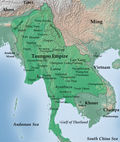
File:Map-of-southeast-asia 900 CE.png for geographic names. Baker, Chris. Phongpaichit, Pasuk. A History of Ayutthaya: Siam in the Early Modern World....
(950 × 1,121 (1.5 MB)) - 18:29, 12 August 2023

DescriptionSeal of Ayutthaya (King Narai).png Seal of the Kingdom of Ayutthaya during King Narai's rule. Date 24 December 2011 Source Original Source...
(400 × 400 (70 KB)) - 12:44, 1 November 2020

File:BlankMap-Thailand-provinces.svg licensed with cc-by-sa-3.0 7 October 2011 Paul_012 1051x1849 (1MB) {{Information|Description={{en|1=Map of Thailand...
(448 × 399 (57 KB)) - 09:39, 13 August 2021

DescriptionMap-of-southeast-asia 1400 CE.png English: Map of Southeast Asia circa 1400 CE, showing Khmer Empire in red, Ayutthaya Kingdom in violet, Lan Xang kingdom...
(791 × 1,114 (190 KB)) - 14:37, 2 July 2023

File:BlankMap-Thailand-provinces.svg licensed with Cc-by-sa-3.0 7 October 2011 Paul_012 1051x1849 (1MB) "classified rivers{{Information|Description={{en|1=Map...
(900 × 1,584 (571 KB)) - 15:09, 14 October 2020

Record, Long Lost, of How Ayutthaya Was Conquered. Journal of the Siam Society. https://thesiamsociety.org/wp-content/uploads/2011/04/JSS_099_0d_SoeThuza...
(286 × 377 (45 KB)) - 14:07, 16 April 2024

(อุดรธานี) Yasothon (ยโสธร) Bueng Kan (New province from 2011-03-23) Central Ang Thong (อ่างทอง) Ayutthaya (พระนครศรีอยุธยา) Bangkok (กรุงเทพฯ) Chainat (ชัยนาท)...
(268 × 450 (29 KB)) - 20:49, 3 September 2020

towards Ayutthaya City, in the Burmese-Siamese War (1765-1767): Line A: Lampang - Tak - Kamphaeng Phet - Sukhothai - Phitsanulok - Ayutthaya; Line B:...
(1,516 × 2,657 (461 KB)) - 14:57, 4 April 2024

towards Ayutthaya City, in the Burmese-Siamese War (1765-1767): Line A: Lampang - Tak - Kamphaeng Phet - Sukhothai - Phitsanulok - Ayutthaya; Line B:...
(1,516 × 2,657 (1.04 MB)) - 00:58, 13 January 2024