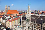
Langwieder lake district. River surfing is a popular sport in Munich. The Flosskanal wave in the south of Munich is less challenging. A well visited surfing...
194 KB (17,061 words) - 19:15, 15 October 2024
The Elsterwerda–Grödel raft canal (German: Elsterwerda-Grödel-Floßkanal), established in the 18th century, serves as a waterway connecting the Pulsnitz...
42 KB (5,463 words) - 07:08, 10 August 2024

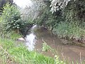
of Thalkirchen in southern Munich, which flows from the left into the Floßkanal. Adolf Wenz (1840–1927), namesake of the settlement and the stream, ran...
4 KB (245 words) - 18:28, 29 July 2024
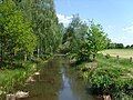
The Floßbach (also Floßgraben or Floßkanal, formerly Flotzbach or Flotzbachgraben) is a man-made river 16 kilometres (9.9 mi) long. It is an orographically...
3 KB (151 words) - 18:20, 30 August 2022

Höntzsch: Die Große Röder – eine Lebensader unserer Region in 250 Jahre Floßkanal Grödel-Elsterwerda 1748-1998. Ed.: Elsterwerda Heritage Society and Environment...
41 KB (5,131 words) - 14:16, 21 May 2024
article at [[:de:Floßkanal (München)#Abzweige]]; see its history for attribution. You may also add the template {{Translated|de|Floßkanal (München)#Abzweige}}...
1 KB (30 words) - 05:34, 16 December 2019

of Bahnhofstraße 41. Bahnhofstraße, Sauerlacher Straße and Straße Am Floßkanal run to the west of the tracks. In the south of the station building is...
23 KB (2,745 words) - 18:08, 12 August 2024

3.873 km, 14.446 km²) (left-hand branch from Schlierbach to the Wiese)Floßkanal (232-74-2; 5.544 km) + 7.461 km² (r) Steinenbach (232-8; 13.683 km; 46...
33 KB (4,447 words) - 17:30, 15 June 2024