
Fourche Maline (pronounced foosh-ma-lean) (Bad Fork, French) is a 70.0-mile-long (112.7 km) tributary of the Poteau River in Oklahoma. The headwaters...
4 KB (447 words) - 10:00, 18 June 2024
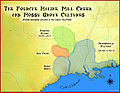
The Fourche Maline culture (pronounced foosh-ma-lean) was a Woodland Period Native American culture that existed from 300 BCE to 800 CE, in what are now...
8 KB (772 words) - 10:00, 18 June 2024
River Mississippi River (AR) Arkansas River Poteau River James Fork Fourche Maline Lee Creek Sans Bois Creek Little Sans Bois Creek Sallisaw Creek Canadian...
9 KB (497 words) - 22:00, 10 March 2024

Poteau River (category Bodies of water of Le Flore County, Oklahoma)
serves as a border between Oklahoma and Arkansas for a short distance. Tributaries of the Poteau River include the Fourche Maline, the Brazil Creek, and the...
9 KB (826 words) - 17:58, 18 April 2024
This is a list of current and former state parks in Oklahoma. "Bernice Area at Grand Lake State Park". TravelOK.com. Retrieved July 31, 2020. "Honey Creek...
19 KB (195 words) - 03:36, 13 November 2023

State of Oklahoma During prehistoric times, Pushmataha County was part of the territory during the Middle Woodland period of the Fourche Maline culture...
43 KB (4,901 words) - 23:04, 2 July 2024
Sugar Loaf County, Choctaw Nation (category Oklahoma articles missing geocoordinate data)
along Cavanal Mountain and adjacent ridges, following Cedar Creek, Fourche Maline, and the Poteau River. Its eastern border was with Arkansas, and its...
5 KB (729 words) - 04:33, 7 November 2023

reaching across the Mississippi River to the east around Natchez, and the Fourche Maline culture in the northwestern part of the state. The Marksville culture...
250 KB (22,603 words) - 15:17, 2 October 2024
Cartography by Miklos Pinther; The Newberry Library, University of Oklahoma Press; Norman, Oklahoma; 1987 Erie History by Dick Shovel The Calumet Region; Indiana's...
41 KB (3,900 words) - 01:39, 9 September 2024