
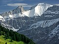
The Gstellihorn (2,855 m) is a mountain of the Bernese Alps, located west of Innertkirchen in the Bernese Oberland. It is the highest summit of the Engelhörner...
1 KB (62 words) - 16:10, 22 April 2024

42056°N 9.26361°E / 46.42056; 9.26361 Lepontine Alps Graubünden 257 321 Gstellihorn 2,855 9,367 366 1,201 46°39′44″N 08°10′29″E / 46.66222°N 8.17472°E...
112 KB (1,337 words) - 21:15, 20 July 2024
Highest point Elevation 2,782 m (9,127 ft) Prominence 92 m (302 ft) Parent peak Gstellihorn Coordinates 46°40′19.7″N 8°10′48″E / 46.672139°N 8.18000°E / 46.672139;...
1 KB (71 words) - 22:21, 29 September 2021

436 ft) Bettmerhorn 2,872 m (9,423 ft) Gallauistöck 2,869 m (9,413 ft) Gstellihorn 2,855 m (9,367 ft) Innerer Fisistock 2,787 m (9,144 ft) Grosses Engelhorn...
24 KB (1,279 words) - 07:52, 22 May 2024

Sanetschhore 2,924 metres (9,593 ft) Dent Favre 2,916 metres (9,567 ft) Gstellihorn 2,820 metres (9,252 ft) Petit Muveran 2,810 metres (9,219 ft) Culan 2...
3 KB (124 words) - 07:38, 21 May 2024
Sanetschhore ‹See Tfd›German: Sanetschhorn, French: Mont Brun The Gstellihorn (left) and the Sanetschhorn (right) from above Les Diablerets Highest point...
2 KB (69 words) - 09:04, 25 April 2024
I/A-05.IV-A Isère FR 693 Gstellihorn 2855 366 46°39′44″N 08°10′29″E / 46.66222°N 8.17472°E / 46.66222; 8.17472 (693. Gstellihorn (2855 m)) Vaud Alps I/B-12...
94 KB (827 words) - 18:10, 4 August 2024
7.72972°E / 46.52028; 7.72972 Bernese Alps Frutigen-Niedersimmental Gstellihorn 2855 366 46°39′44″N 08°10′29″E / 46.66222°N 8.17472°E / 46.66222;...
27 KB (312 words) - 06:35, 6 May 2024