
Sai Kung District is one of the 18 districts of Hong Kong. The district comprises the southern half of the Sai Kung Peninsula, the Clear Water Bay Peninsula...
26 KB (2,985 words) - 02:59, 15 August 2024

Sai Kung Town (Chinese: 西貢市), or simply Sai Kung (Chinese: 西貢), is a town on the Sai Kung Peninsula facing Sai Kung Hoi (Inner Port Shelter, part of Sai...
21 KB (1,984 words) - 02:19, 19 August 2024
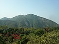
Kai Kung Shan (Chinese: 雞公山) is a mountain which lies within the western part of Sai Kung Peninsula in northeastern Hong Kong. Its summit is 399 metres...
1 KB (82 words) - 14:21, 11 October 2021
Kai Kung Shan (Chinese: 雞公山) is the name of several hills in Hong Kong: Kai Kung Shan (Sai Kung District) (399 metres (1,309 ft)) in Sai Kung District...
398 bytes (94 words) - 02:37, 11 November 2023

The Sai Kung District Council (Chinese: 西貢區議會) is the district council for the Sai Kung District in Hong Kong. It is one of 18 such councils. The Sai Kung...
17 KB (628 words) - 18:01, 26 July 2024

area is served by Sai Sha Road, a motorway between Sai Kung and Ma On Shan. Geographically it is a practical exclave of Tai Po District, along with Shek...
3 KB (242 words) - 02:43, 5 May 2024
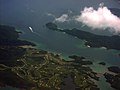
Kong. It is under the administration of Sai Kung District. The island was formerly known as Keui Island. 'Kau Sai Chau', the transliteration of the Chinese...
13 KB (1,084 words) - 21:02, 6 July 2024
Tolo Highway linking Sha Tin to the northern districts, and Sai Sha Road linking Ma On Shan to Sai Kung. A network of cycle tracks throughout Sha Tin...
18 KB (1,944 words) - 05:55, 27 July 2024

Harbour, northwest of Ma On Shan in the New Territories, Hong Kong. Wu Kai Sha is within the Sha Tin District, one of the 18 districts of Hong Kong. The name...
6 KB (680 words) - 06:00, 27 July 2024

MacLehose Trail (section Sai Kung)
Hong Kong, starting from Pak Tam Chung, Sai Kung District in the east to Tuen Mun Town, Tuen Mun District in the west. It is the longest trail in Hong...
67 KB (6,297 words) - 09:36, 24 March 2024