
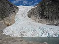
Summit seen from Bohr glacier Lodalskåpa (in the left) seen from Myklebustbreen in the west. Seen from west "Lodalskåpa, Luster (Sogn og Fjordane)" (in...
3 KB (246 words) - 15:24, 13 September 2022

Luster, Sogndal, Sunnfjord, and Stryn. The highest peak in the area is Lodalskåpa at a height of 2,083 metres (6,834 ft). In 1906, work was being done on...
5 KB (439 words) - 22:28, 22 March 2024

Nunatak Lee Nunatak Lepley Nunatak Lewisohn Nunatak Lilliput Nunataks Lodalskåpa Lonely One Nunatak Lonewolf Nunataks Longs Nunatak López Nunatak Luck...
10 KB (1,004 words) - 23:37, 26 February 2024

Dalsnibba Dalsnibba (Norway) Show map of Norway Location Møre og Romsdal, Norway Parent range Sunnmørsalpene Topo map 1219 II Geiranger and 1418 IV Lodalskåpa...
3 KB (247 words) - 15:47, 27 July 2024
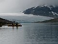
bremuseum in Fjærland (Sogndal Municipality). The highest peak in the park is Lodalskåpa at 2,083 metres (6,834 ft). The glacier's highest point, Brenibba, lies...
3 KB (249 words) - 07:15, 2 May 2024

Vestland Skåla Skåla (Norway) Show map of Norway Location Vestland, Norway Parent range Breheimen Topo map 1318 I Stryn (west) and 1418 IV Lodalskåpa (east)...
4 KB (419 words) - 21:01, 26 May 2024
lakes are Oppstrynsvatn, Lovatnet, and Oldevatnet. The mountains Skåla, Lodalskåpa, and Høgstre Breakulen are all located in Stryn. The Jostedalsbreen National...
34 KB (2,307 words) - 00:02, 6 August 2024

Spørteggbreen. Some of the major mountains in the area include Skåla, Lodalskåpa, Høgste Breakulen, Tverrådalskyrkja, Hestbrepiggene, and Brenibba. The...
3 KB (153 words) - 01:47, 25 November 2023
river Jostedøla. The lake is about 10 kilometres (6.2 mi) to the east of Lodalskåpa and Brenibba in Jostedalsbreen National Park. Styggevatnet lies about...
3 KB (145 words) - 18:58, 23 September 2023
62.31611°N 9.20250°E / 62.31611; 9.20250 122 Lodalskåpa 2083 760 Luster / Stryn 1418 IV "Lodalskåpa" 25980 61°47′26″N 7°12′18″E / 61.79056°N 7.20500°E...
33 KB (349 words) - 15:59, 21 September 2024