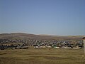
Mukhorshibir (‹See Tfd›Russian: Мухоршиби́рь; Buryat: Мухар Шэбэр, Mukhar Sheber) is a rural locality (a selo) and the administrative center of Mukhorshibirsky...
3 KB (664 words) - 19:25, 24 January 2023
Kyakhta 39785 Mukhorshibirsky District Мухоршибирский район selo of Mukhorshibir 24969 Muysky District Муйский район urban-type settlement of Taksimo...
276 KB (538 words) - 12:12, 5 October 2024

locality (a selo) of Mukhorshibir. As of the 2010 Census, the total population of the district was 24,969, with the population of Mukhorshibir accounting for...
6 KB (773 words) - 13:43, 15 December 2023

Kurumkan R-439: R-440 "Dzhidinskiy trakt": Gusinoozyorsk - Zakamensk R-441: Mukhorshibir - Bichura - Kyakhta R-442: R-448: Lazo - Preobrazheniye R-449: Route...
33 KB (2,030 words) - 01:21, 16 July 2024

Oblast Military commissariat Molotov attack 0 0 No damage 17 October 2022 Mukhorshibir, Buryatia Military commissariat Molotov attack 0 0 Burnt facade 26 October...
84 KB (3,419 words) - 06:01, 4 October 2024
Kharashibir is located 14 km northeast of Mukhorshibir (the district's administrative centre) by road. Mukhorshibir is the nearest rural locality. Карта Мухоршибирского...
2 KB (75 words) - 12:46, 28 September 2024
356 as of 2010. There are 5 streets. Kugoty is located 26 km west of Mukhorshibir (the district's administrative centre) by road. Zandin is the nearest...
2 KB (73 words) - 12:46, 28 September 2024
737 as of 2010. There are 19 streets. Tsolga is located 46 km west of Mukhorshibir (the district's administrative centre) by road. Balta is the nearest...
2 KB (73 words) - 12:46, 28 September 2024
of 2010. There are 7 streets. Stepnoy is located 49 km northeast of Mukhorshibir (the district's administrative centre) by road. Tugnuy is the nearest...
2 KB (68 words) - 12:47, 28 September 2024
301 as of 2010. There are 4 streets. Balta is located 53 km west of Mukhorshibir (the district's administrative centre) by road. Tsolga is the nearest...
2 KB (70 words) - 12:46, 28 September 2024