300km 200miles NJ9842 NJ9842, also called NJ 980420 (in full: NJ 38 98000, 13 42000, yard based Indian Grid Coordinates), is the northernmost demarcated...
10 KB (1,069 words) - 03:56, 27 May 2023

421226°N 77.109540°E / 35.421226; 77.109540, just northeast of the point NJ9842 where the Line of Control between India and Pakistan ends. At 76 km (47 mi)...
44 KB (4,193 words) - 11:19, 15 August 2024
demarcated Point NJ9842 was "thence north to the glaciers." Pakistan interpretation was that their territory continued northeast from Point NJ9842 to the Karakoram...
20 KB (2,138 words) - 16:42, 3 August 2024
then northeastwards to the map coordinate NJ9842, about 19 km north of the Shyok river. From the map point NJ9842, it was said to run due north to the international...
13 KB (1,130 words) - 13:11, 28 January 2024

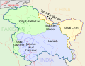
Chicken's Neck in Pakistan to Point NJ9842, and Actual Ground Position Line (AGPL) across Siachen from Point NJ9842 to Indira Col West. Siachen lies south...
11 KB (891 words) - 06:26, 5 October 2023
incompletely demarcated territory on the map beyond the map coordinate known as NJ9842 (35°00′30″N 77°00′32″E / 35.008371°N 77.008805°E / 35.008371; 77.008805)...
73 KB (6,944 words) - 02:57, 22 August 2024
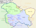
Chicken's Neck in Pakistan to Point NJ9842, and Actual Ground Position Line (AGPL) across Siachen from Point NJ9842 to Indira Col West. Siachen lies south...
23 KB (2,366 words) - 21:55, 14 August 2024

astronomical observatories Near the AGPL (Actual Ground Position Line) NJ9842 (peak) LoC ends and AGPL begins here Gharkun (peak) Gyong Kangri (peak)...
13 KB (1,361 words) - 14:23, 17 February 2024
territory running from the last defined point in the 1949 Karachi Agreement, NJ9842, east-northeast to the Karakoram Pass, thus putting the whole of Saltoro...
7 KB (665 words) - 21:53, 2 January 2024
Sia La Ghent Kangri Saltoro Kangri Bilafond La Chumik Glacier Gyong La NJ9842 "Topographic map of K12". opentopomap.org. Retrieved 2023-06-19. "High Asia...
4 KB (344 words) - 00:35, 17 July 2024