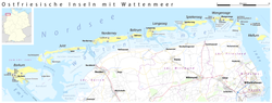
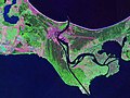
The Norderneyer Seegatt or (officially) Norderneyer Seegat is a gat in the southern North Sea. The gat runs in a north–south direction between the East...
1 KB (132 words) - 14:21, 28 July 2022
A gat (Dutch: zeegat, gat; German: Seegatt, Seegat or diminutive Gatje) is an inshore channel or strait connecting coastal waters with the open sea or...
8 KB (956 words) - 09:37, 6 July 2024
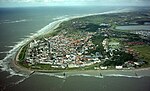
about 3 kilometres (1.9 mi) away on the other side of the Norderneyer Seegatt. The entire eastern half of Norderney belongs to the Lower Saxon Wadden...
13 KB (1,161 words) - 11:51, 7 June 2024
Harle (gat) (redirect from Harle-Seegatt)
The Harle or the Harle Seegatt is a gat in the North Sea. The Harle runs in a north-south direction between the East Frisian Islands of Spiekeroog and...
3 KB (292 words) - 11:30, 12 July 2024

Juist, and Loog. The island is separated from Norderney by the Norderneyer Seegatt. The tallest buildings on Juist that can be seen from the North Sea are...
6 KB (665 words) - 20:27, 22 March 2024
the Prerower Strom in northeast Germany and the Świna in northwest Poland. Neues Tief bei Pillau als Seegatt landschaften/prerowstrom/prerowstrom.html...
2 KB (113 words) - 12:07, 22 January 2017

National Park. The Prerower Strom is not a river, but a so-called "gat" (Seegatt) or inlet, and was not formed until the first millennium A.D. when the...
3 KB (483 words) - 09:50, 28 December 2023