
L'Échelle (French pronunciation: [leʃɛl]) is a commune in the Ardennes department and Grand Est region of north-eastern France. Communes of the Ardennes...
2 KB (76 words) - 12:22, 24 August 2024

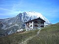
Col de l'Échelle (el. 1762 m., in Italian Colle della Scala) is a mountain pass in the Alps in the department of Hautes-Alpes in France. It is the lower...
2 KB (187 words) - 13:21, 8 October 2022
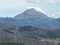
The Pointe de l'Échelle (3,442 m) is a mountain in the Vanoise Massif in Savoie, France. "Pointe de la l'Échelle - Peakvisor". peakvisor.com. Retrieved...
1 KB (30 words) - 17:55, 17 April 2022
Le Plessis-l'Échelle (French pronunciation: [lə plɛsi leʃɛl]) is a commune in the Loir-et-Cher department of central France. Communes of the Loir-et-Cher...
2 KB (84 words) - 11:55, 29 August 2024

L'Échelle-Saint-Aurin is a commune in the Somme department in Hauts-de-France in northern France. The commune is situated 32 kilometres (20 mi) southeast...
2 KB (111 words) - 06:14, 10 May 2023

highest neighbour is the Pic de Noé. Source : Géoportail avec carte IGN à l'échelle 1:25000 "Pic de Soularac, France". Peakbagger.com. Retrieved 19 December...
1 KB (63 words) - 14:35, 21 January 2023
Canadian Rockies Mount Lefroy 3,423 11,230 Canadian Rockies Pointe de l'Échelle 3,422 11,227 Vanoise massif, France Pointe du Bouchet 3,420 11,220 Vanoise...
139 KB (176 words) - 03:23, 5 September 2024
Laboratory. Retrieved July 30, 2023. KERAUNOS. "Intensité des tornades : l'échelle de Fujita améliorée". Suzuki, Shota; Tanaka, Yoshinobu. "The Japanese...
33 KB (2,330 words) - 00:26, 24 August 2024
mainland France. Mountains of Catalonia Source : Géoportail avec carte IGN à l'échelle 1:25000 "Mapa Topogràfic de Catalunya". Institut Cartogràfic de Catalunya...
1 KB (66 words) - 22:21, 22 January 2018

Cottian Alps, located on the Main chain of the Alps NW of the Col de l'Échelle. In French aiguille means needle and rouge means red. In Italian too rossa...
4 KB (352 words) - 12:38, 11 August 2024