Surveyors Range (81°37′S 160°15′E / 81.617°S 160.250°E / -81.617; 160.250) is a 30 miles (48 km) long mountain range in the Churchill Mountains of...
14 KB (1,832 words) - 19:24, 9 March 2024
professional body of surveyors. Chartered Surveyors are entitled to use "MRICS" or "FRICS" after their names as appropriate. Chartered Surveyors are highly trained...
15 KB (1,444 words) - 20:37, 27 March 2024

hours (2.7 days). The launch weights (at lunar injection) of the seven Surveyors ranged from 995.2 kilograms (2,194 lb) to 1,040 kilograms (2,290 lb), and...
10 KB (1,037 words) - 17:02, 21 August 2024


Churchill Mountains (category Mountain ranges of the Ross Dependency)
Nimrod Glacier. Surveyors Range (81°37′S 160°15′E / 81.617°S 160.250°E / -81.617; 160.250 (Surveyors Range)), a 30 miles (48 km) long range extending north...
10 KB (1,231 words) - 16:22, 14 March 2024
for marine surveyors. The U.S. Coast Guard does not approve or certify marine surveyors; however, it adopted Navtech USSA Marine Surveyor practices in...
14 KB (1,818 words) - 16:39, 20 June 2024

the Institution of Surveyors, it received a royal charter in 1881, and in 1947 became the Royal Institution of Chartered Surveyors. With a London HQ and...
49 KB (4,924 words) - 09:32, 27 June 2024
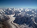
Karakoram (redirect from Karakoram Range)
explorers first visited early in the 19th century, followed by British surveyors starting in 1856. The Muztagh Pass was crossed in 1887 by the expedition...
29 KB (2,541 words) - 00:51, 28 September 2024
Ahern Glaciers to the west side of Starshot Glacier. It faces the Surveyors Range on the east side of the Starshot Glacier. It was named by the New Zealand...
8 KB (788 words) - 23:05, 11 July 2024
southern end of the range. The Holyoake Range lies to the southwest of the Nash Range. The Surveyors Range is to the northwest. The range was named by the...
12 KB (1,641 words) - 16:13, 31 August 2024