based in Manas County, according to the History of Manas County (玛纳斯县历史沿革), also see 玛纳斯县历史沿革. xzqh.org. 2015-02-10. Retrieved 2019-08-30. the 2010 census...
29 KB (2,556 words) - 22:27, 1 September 2024
autonomous banners, and banners) along with county-level cities (Chinese: 县级市; pinyin: xianjí shì) and city districts (Chinese: (市辖)区; pinyin: (shìxiá)...
309 KB (97 words) - 13:41, 27 August 2024
529 21.24 Hutubi County 呼图壁县 Hūtúbì Xiàn خُتُبِ ثِیًا قۇتۇبى ناھىيىسى Qutubi Nahiyisi 192,638 9,518 20.24 Manas County 玛纳斯县 Mǎnàsī Xiàn مَانَاسِ ثِیًا...
11 KB (236 words) - 08:45, 15 June 2024

Maralbexi County (redirect from 巴楚县)
transliterated from Uyghur: مارالبېشى ناھىيىسى; Chinese: 玛热勒巴什县), Bachu County (Chinese: 巴楚县), and Chinese: 巴尔楚克县) the former long Chinese name as well, is located...
25 KB (1,776 words) - 14:05, 9 October 2024
Nahiyisi; SASM/GNC (broad): arkol Kazak Aptonom Nahiyisi; Chinese: 巴里坤哈萨克自治县; pinyin: Bālǐkūn Hāsàkè Zìzhìxiàn Conventional name: Changji Hui Autonomous...
61 KB (755 words) - 07:36, 30 August 2024
Co. 昌吉县 652322 Miquan Co. 米泉县 652323 Hutubi Co. 呼图壁县 652324 Manas Co. 玛纳斯县 652325 Qitai Co. 奇台县 652326 Fukang Co. 阜康县 652327 Jimsar Co. 吉木萨尔县 652328...
55 KB (14 words) - 06:47, 22 October 2023
]178号)批复同意撤销塔提让乡,设立塔提让镇,并将县直辖的26848平方公里划归塔提让镇管辖。调整后,全县辖3个镇、9个乡:且末镇、奥依亚依拉克镇、塔提让镇、阿热勒乡、琼库勒乡、托格拉克勒克乡、巴格艾日克乡、英吾斯塘乡、阿克提坎墩乡、阔什萨特玛乡、阿羌乡、库拉木勒克乡。 Xinjiang: Prefectures...
31 KB (2,422 words) - 14:30, 18 May 2024

Hankkazitan Kazakh Ethnic Township (旱卡子滩哈萨克族乡) Other (其他) 玛纳斯发电有限责任公司 | 玛纳斯园艺场 | 玛纳斯平原林场 | 农科院玛纳斯试验站 | 农六师新湖农场 | 兵团农八师(147团场 | 148团场 | 149团场 | 150团场) Town...
138 KB (18,140 words) - 22:36, 29 August 2024

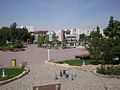
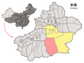
Manas County 玛纳斯县 (Chinese) ماناس ناھىيىسى (Uyghur) Manass County Location of Manas County (pink) in Changji Prefecture (yellow) and Xinjiang (grey) Manas...
14 KB (210 words) - 15:16, 18 May 2024
Kejimata (克吉玛塔村) Terek (Tiereke, Tierekecun; تېرەك كەنت / 铁热克村) 41°08′50″N 082°47′06″E / 41.14722°N 82.78500°E / 41.14722; 82.78500 Kuonatiereke (阔纳铁热克村)...
20 KB (2,035 words) - 14:13, 9 October 2024