
Kongur Tagh, which means "a brown mountain" in Uyghur language, has a significant subpeak known as Kongur Tiube (公格尔九别峰 which means in the local language...
2 KB (181 words) - 12:31, 29 January 2024

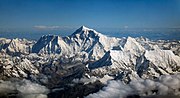
not be 7,719 m (25,325 ft) high. Kongur Tagh Karakoram Highway Kashgar Xinjiang China Kongur Tagh (left) and Kongur Tiube (slightly to the right) as seen...
5 KB (507 words) - 01:24, 28 April 2024

others. The Pamir River is in the south-west of the Pamirs. Kongur Tagh (left) and Kongur Tiube (slightly to the right) as seen from the Karakoram Highway...
32 KB (3,088 words) - 13:07, 18 July 2024

peaks visible from the lake are the Muztagh Ata (7,546 m), Kongur Tagh (7,649 m) and Kongur Tiube (7,530 m). The meltwater from the nearby Muztagh Ata glaciers...
4 KB (336 words) - 01:49, 30 January 2023
m)) Gangkhar Puensum 1986 China Bhutan 46 Kongur Tiube 7,530 metres (24,700 ft) 840 metres (2,760 ft) Kongur Shan (Eastern Pamirs) 38°36′57″N 75°11′45″E...
58 KB (2,253 words) - 13:14, 12 July 2024

above sea level; the highest peak of Kongur Tagh (公格尔山) in the central part is 7,719 meters above sea level, Kongur Tiube (公格尔九别峰) is 7,530 meters, and Muztagh...
40 KB (2,737 words) - 04:21, 18 July 2024

level. The township's highest point, Kongur Tiube, is 7,719 metres (25,325 ft) above sea level. The mountains of Kongur Tagh and Muztagh Ata are cascaded...
17 KB (1,413 words) - 10:35, 19 October 2023