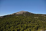
including the 110-mile (180 km) Metacomet-Monadnock Trail and the 50-mile (80 km) Monadnock-Sunapee Greenway. The summit is barren largely because of fires...
29 KB (3,416 words) - 19:51, 19 September 2024

The Monadnock-Sunapee Greenway (MSG) is a 50-mile (80 km) hiking trail that traverses the highlands of southern New Hampshire from Mount Monadnock in Jaffrey...
13 KB (1,377 words) - 14:40, 3 April 2024

ridge is traversed by the Monadnock-Sunapee Greenway, a hiking trail that links the summit of Sunapee with that of Mount Monadnock, 50 miles (80 km) to the...
11 KB (758 words) - 13:16, 20 July 2024
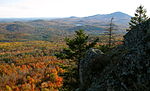
the Andrew Brook Trail, the Newbury Trail, or the long-distance Monadnock-Sunapee Greenway Trail. White Ledge, elevation 2,720 feet (830 m), rises steeply...
3 KB (214 words) - 16:18, 12 July 2022
Metacomet-Monadnock Trail, a 110 mi (180 km) hiking trail located in western Massachusetts and southern New Hampshire Monadnock-Sunapee Greenway, a 50 mi...
1 KB (196 words) - 22:07, 4 November 2018

Minneapolis Monadnock-Sunapee Greenway, 50-mile mountainous trail in southwestern New Hampshire (not a paved or shared-use path) Mountains to Sound Greenway, 150...
24 KB (2,673 words) - 16:14, 10 July 2024
on the summit of Mount Monadnock in southern New Hampshire. The Metacomet Trail in Connecticut and the Monadnock-Sunapee Greenway Trail in New Hampshire...
31 KB (3,502 words) - 11:54, 4 September 2024

{{cite web}}: CS1 maint: postscript (link) "About the Bay Circuit Trail & Greenway". Bay Circuit Alliance. Retrieved 2021-01-24More than 230 miles of multi-use...
42 KB (537 words) - 03:51, 23 September 2024

Baldhead Mountain 2,729 feet (832 m) Mount Sunapee 2,726 feet (831 m) Mount Sunapee Resort, Monadnock-Sunapee Greenway Piermont Mountain 2,717 feet (828 m)...
52 KB (888 words) - 21:15, 13 May 2024
the 75-mile (120 km) Sunapee-Ragged-Kearsarge Greenway hiking trail which links 10 towns and encircles the Kearsarge-Lake Sunapee region of western New...
7 KB (724 words) - 08:50, 21 August 2024