Montauk Highway is an east–west road extending for 95 miles (153 km) across the southern shore of Long Island in Suffolk County, New York, in the United...
32 KB (2,522 words) - 17:40, 25 July 2024

New York State Route 27 (redirect from Montauk Point State Parkway)
(194.05 km) long state highway that runs east–west from Interstate 278 (I-278) in the New York City borough of Brooklyn to Montauk Point State Park on Long...
51 KB (4,115 words) - 17:45, 25 July 2024
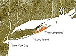
colonies of the northeastern United States. The Montauk Branch of the Long Island Rail Road, the Montauk Highway, and private bus services connect the Hamptons...
30 KB (2,859 words) - 18:58, 12 July 2024

tip of Long Island, at 2000 Montauk Highway, is a privately run museum, and is not part of Montauk Point State Park. Montauk Light was the first lighthouse...
17 KB (1,799 words) - 20:57, 15 June 2024
List of county routes in Suffolk County, New York (26–50C) (redirect from Corporal Tony Casamento Highway)
intersections The entire route is located in Montauk. County Route 31 is a short north-south county highway running across rural eastern Suffolk County...
71 KB (6,018 words) - 16:06, 25 July 2024

and CR 94 in Riverside. Route description The road begins at CR 80 (Montauk Highway) just east of the eastern terminus of CR 98 (Frowein Road). The route...
68 KB (5,459 words) - 17:28, 25 July 2024

The Montauk Branch is a rail line owned and operated by the Long Island Rail Road in the U.S. state of New York. The line runs the length of Long Island...
36 KB (2,455 words) - 02:04, 30 June 2024
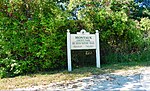
in size, running from Montauk Highway north to Block Island Sound and is bordered on the east by Montauk Point State Park. Montauk County Park was created...
10 KB (1,141 words) - 15:20, 20 June 2024

southern side of Montauk Highway the water reached up to 6 feet (1.8 m) high. When multiple fires broke out south of Montauk Highway, firefighters were...
16 KB (1,630 words) - 18:58, 22 June 2024

line between Nassau and Suffolk into Amityville, where it becomes Montauk Highway at the Amityville–Copiague village/hamlet line. The easternmost portion...
12 KB (831 words) - 16:08, 25 July 2024