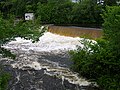
Quinebaug Lake State Park is a public recreation area covering 181 acres (73 ha) in the town of Killingly, Connecticut. The state park offers opportunities...
6 KB (295 words) - 04:13, 31 July 2024
The Quinebaug Highlands are a 172,000 acre region of mountains surrounding the Connecticut/Massachusetts border near Ashford, Eastford, Union, and Woodstock...
4 KB (293 words) - 14:39, 25 April 2024
Killingly Quinebaug Trout Hatchery, Plainfield Robert Manship Park off Route 14, Canterbury Butts Bridge Road, Canterbury Brimfield Lake and Dam on the...
12 KB (577 words) - 04:20, 5 April 2024
Connecticut Quaddick State Park, Thompson, Connecticut Quinebaug Lake State Park, Killingly, Connecticut Ross Pond State Park, Killingly, Connecticut...
9 KB (734 words) - 09:06, 30 July 2024

Gillette Castle State Park straddles the towns of East Haddam and Lyme, Connecticut in the United States, sitting high above the Connecticut River. The...
14 KB (1,346 words) - 03:03, 4 June 2024
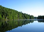
Bigelow Hollow State Park is public recreation area in the town of Union, Connecticut, in the Quinebaug Highlands. The state park's 516 acres (209 ha)...
7 KB (537 words) - 13:07, 3 August 2024
This is a list of state parks, reserves, forests and wildlife management areas (WMAs) in the Connecticut state park and forest system, shown in five tables...
72 KB (153 words) - 23:20, 20 June 2024

Lake Wyola State Park, also known as the Carroll A. Holmes Recreation Area, is located in the town of Shutesbury, Massachusetts. It is a state-run recreation...
3 KB (164 words) - 19:03, 13 October 2023

The Quinebaug Trail is a 8.1-mile (13.0 km) Connecticut hiking trail and is one of the Blue-Blazed hiking trails maintained by the Connecticut Forest...
16 KB (2,011 words) - 02:54, 29 December 2022
coordinates) GPX (secondary coordinates) This list of Massachusetts State Parks contains the state parks and recreation areas in the Commonwealth of Massachusetts...
66 KB (248 words) - 18:13, 15 February 2024