Río Bravo Airport (Spanish: Aeropuerto Río Bravo, (ICAO: SCRB)) is an airstrip 36 kilometres (22 mi) southeast of Caleta Tortel in the Aysén Region of...
2 KB (127 words) - 02:39, 3 April 2023

Rio Bravo is a city in Webb County, Texas, United States. It lies16 miles (26 km) south of Laredo on U.S. Route 83, on the left bank of the Rio Grande...
14 KB (1,100 words) - 21:29, 22 July 2024

Villa Puerto Edén. The village is served by Caleta Tortel Airport (IATA: SCCR). Río Bravo Airport (IATA: SCRB), 37 kilometres (23 mi) southeast of Caleta...
6 KB (356 words) - 13:09, 8 November 2023

Bernalillo County/International Sunport station (redirect from Rio Bravo/Airport (Rail Runner station))
Mexico, United States. It is located on Second Street, just north of Rio Bravo, and is accessible via Second Street and Prince Street. It serves the...
4 KB (209 words) - 21:24, 1 June 2024
County, US Rio, Wisconsin, a village in Columbia County, US El Río, Las Piedras, Puerto Rico, a barrio Río Arriba, Añasco, Puerto Rico, a barrio Río Arriba...
12 KB (1,512 words) - 09:45, 23 August 2024

Edinburg, Mission, San Juan, and Rio Grande City metropolitan areas in the United States and the Matamoros, Río Bravo, and Reynosa metropolitan areas in...
74 KB (6,409 words) - 04:45, 13 August 2024
This is a list of airports in Chile, sorted by location. Airport names shown in bold indicate the airport has scheduled commercial airline service. Links...
42 KB (148 words) - 04:55, 11 November 2023

Ciudad Acuña (category Coahuila populated places on the Rio Grande)
height above sea level of 271 m (889 ft). It stands on the Rio Grande (locally known as the Río Bravo), which marks the U.S.-Mexico border, and offers two border...
16 KB (1,342 words) - 06:39, 2 June 2024
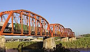
This is a list of bridges and other crossings of the Rio Grande (Río Bravo del Norte), from the Gulf of Mexico, upstream to its source. Map all coordinates...
16 KB (184 words) - 19:47, 1 August 2024

Tamaulipas (section Airports)
correspond to the areas destined for agricultural use. The Rio Grande, known to Mexicans as the Río Bravo, represents the northern frontier shared with the United...
46 KB (3,840 words) - 23:51, 12 August 2024