
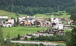
Savognin (in local Romansh dialect Suagnign; Italian: Savognino; German: Schweiningen, official name until 1890) is a village and former municipality in...
14 KB (1,510 words) - 12:23, 8 May 2024
municipalities of Bivio, Cunter, Marmorera, Mulegns, Riom-Parsonz, Salouf, Savognin, Sur and Tinizong-Rona merged to form the new municipality of Surses. Cunter...
7 KB (665 words) - 22:48, 22 March 2024


Swiss Bike Cup 2nd Savognin 2022 1st Cross-country, National Junior Championships Junior Swiss Bike Cup 1st Rickenbach 1st Savognin 2nd Basel 2nd Cross-country...
6 KB (369 words) - 14:53, 10 August 2024
survive mainly in toponyms, including village names such as Tschlin, Scuol, Savognin, Glion, Breil/Brigels, Brienz/Brinzauls, Purtenza, and Trun. Additionally...
169 KB (18,222 words) - 14:48, 9 August 2024

elevation Total distance Total elevation diff. Tiefencastel 851 m - - - - Savognin 1207 m 9 km 356 m 9 km 356 m Rona 1408 m 5 km 201 m 14 km 557 m Mulegns-Sur...
3 KB (244 words) - 13:54, 5 August 2023

Piz Mez is a mountain of the Oberhalbstein Alps, located south of Savognin in the canton of Graubünden. Retrieved from the Swisstopo topographic maps....
1 KB (43 words) - 12:10, 2 May 2022

Villars-sur-Ollon, Les Diablerets-Glacier 3000 (all VD), Leukerbad (VS), Savognin, Scuol, Obersaxen, Breil/Brigels (all GR), Meiringen – Hasliberg (BE),...
36 KB (3,643 words) - 14:41, 29 April 2024

Piz Cartas is a mountain of the Oberhalbstein Alps, located west of Savognin in the canton of Graubünden. Retrieved from the Swisstopo topographic maps...
1 KB (51 words) - 02:21, 1 May 2022

known as Tinzenhorn) is a mountain of the Albula Alps, located between Savognin and Bergün, in the Swiss canton of Graubünden. Its large southern face...
2 KB (54 words) - 13:21, 27 April 2023