
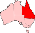
Carnarvon Highway is a state highway in Queensland and New South Wales, Australia, linking the township of Rolleston in Queensland's Central Highlands...
20 KB (1,523 words) - 08:37, 5 January 2024
former spellings. Queensland Carnarvon Range Carnarvon Highway, state highway Carnarvon National Park Carnarvon Gorge Carnarvon Park, Queensland, a locality...
4 KB (536 words) - 01:11, 11 August 2024
Captain Cook Highway Carnarvon Highway Balonne Highway Bunya Highway Moonie Highway Wide Bay Highway Gillies Highway Isis Highway Carnarvon Highway Castlereagh...
5 KB (381 words) - 02:22, 30 July 2024
Gilgandra. Castlereagh Highway commences at an intersection with Carnarvon Highway, south of St George, Queensland, and heads in a south-westerly direction...
21 KB (1,607 words) - 06:36, 13 August 2024

Balonne. It possesses a New South Wales postcode. Mungindi sits on the Carnarvon Highway and straddles the Barwon River which is the border between New South...
27 KB (2,742 words) - 06:30, 13 August 2024

endpoint of the highway. The entire highway is part of the National Highway system linking Darwin and Brisbane: formerly National Highway 54, Queensland...
30 KB (2,105 words) - 12:42, 9 March 2024

landscapes. Carnarvon is the only large settlement on the highway, and is an oasis within the harsh surrounding environment. The entire highway is allocated...
49 KB (4,117 words) - 10:01, 17 January 2024

the Goondiwindi Region and the Shire of Balonne. It starts at the Carnarvon Highway in Nindigully, 44 kilometres south of St George, and travels east...
7 KB (385 words) - 04:02, 21 July 2024

also Ula Ula State Forest and Alton National Park. It ends at the Carnarvon Highway, about 9.1 km from the centre of St George. The first recorded European...
7 KB (549 words) - 10:25, 20 December 2023
between Highway 11 near Bracebridge and Highway 28 near Bancroft. Several communities are served by the route, including Uffington, Vankoughnet, Carnarvon, West...
24 KB (1,967 words) - 17:49, 25 July 2024