
Goulburn-Oberon Road is a New South Wales country road linking Goulburn near Hume Highway to Oberon. This name is not widely known to most drivers, as...
10 KB (806 words) - 00:53, 9 September 2024

Jenolan Caves and Duckmaloi Roads. From Goulburn it is around 140 km (87 mi) north, along the sealed Goulburn-Oberon Road. Relief maps of the area are...
11 KB (979 words) - 00:35, 31 August 2024
Goulburn-Oberon Road from Hume Highway to Oberon, this scenic route provides a leisurely and surprisingly direct route between Bathurst and Goulburn. It is designated...
8 KB (611 words) - 06:31, 13 August 2024

intersection of the Goulburn-Oberon Road and the Laggan-Taralga Road. It is accessible from Oberon to the north, Mittagong to the east, Goulburn to the south...
17 KB (1,674 words) - 00:25, 31 August 2024
Wombeyan Caves Road is a New South Wales country road linking Mittagong near Hume Highway in the east to Goulburn-Oberon Road at the locality of Richlands...
11 KB (1,165 words) - 01:02, 9 September 2024

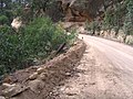
work at Milburne Creek, a minor tributary of the Abercrombie. The Goulburn-Oberon Road crosses the Abercrombie River in the steep-sided Abercrombie Gorge...
7 KB (431 words) - 15:44, 20 July 2023

(48 mi) north of Goulburn. Access is by the Wombeyan Caves Road from either Mittagong in the east or from the Goulburn-Oberon Road in the west. The caves...
8 KB (821 words) - 16:47, 7 July 2024
Federal Highway (Australia) (category WikiProject Australian Roads articles with a junction list using templates)
Highway" (Map). Google Maps. Retrieved 3 August 2022. "OPEN TO-DAY: Road to Canberra". Goulburn Evening Penny Post (DAILY and EVENING ed.). NSW. 25 February...
17 KB (1,156 words) - 00:40, 9 September 2024

Hume Highway (redirect from Great South Road (New South Wales))
Alpine Road (B500), Midland Highway (A300/B300), Goulburn Valley Freeway (M39), Goulburn Valley Highway (B340), Northern Highway (B75), Sydney Road (SR55)...
94 KB (10,495 words) - 12:24, 25 September 2024

Bruxner Highway (category WikiProject Australian Roads articles with a junction list using templates)
alignment as Bruxner Way, are a 420-kilometre (260 mi) state highway and rural road respectively, located in New South Wales, Australia. The route forms an east–west...
17 KB (1,321 words) - 06:21, 13 August 2024