
Inawashiro (猪苗代町, Inawashiro-machi) is a town located in Fukushima Prefecture, Japan. As of 1 March 2020[update], the town had an estimated population...
13 KB (553 words) - 17:05, 7 October 2024

Sukagawa. Fukushima Prefecture is located on Japan's eastern Pacific coast at the southernmost part of the Tōhoku region, and is home to Lake Inawashiro, the...
54 KB (3,743 words) - 03:28, 28 September 2024
Lake Inawashiro (猪苗代湖, Inawashiro-ko) is the fourth-largest lake in Japan, located in central Fukushima Prefecture, south of Mount Bandai. It is also known...
4 KB (307 words) - 12:50, 30 July 2024

Inawashiro Station (猪苗代駅, Inawashiro-eki) is a railway station on the Ban'etsu West Line in the town of Inawashiro, Fukushima, Japan, operated by East...
4 KB (187 words) - 09:19, 4 September 2024

Tenkyōkaku (category Inawashiro, Fukushima)
built as a summer villa for Prince Arisugawa Takehito located in Inawashiro, Fukushima Prefecture, Japan. In August 1907, while touring the Tōhoku region...
5 KB (400 words) - 11:20, 8 October 2024

Aizu Matsudaira clan cemetery (category Inawashiro, Fukushima)
locations. One is in the city of Aizuwakamatsu, Fukushima, and the second is in the town of Inawashiro, Fukushima Japan. The cemetery contains the graves of...
5 KB (476 words) - 14:37, 5 March 2024

Japan National Route 115 (category Roads in Fukushima Prefecture)
Route 115 is a national highway of Japan connecting Sōma, Fukushima and Inawashiro, Fukushima in Japan, with a total length of 109.7 km (68.16 mi). Route...
2 KB (119 words) - 03:07, 9 August 2024
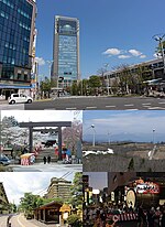
Kōriyama (redirect from Koriyama, Fukushima)
the Nakadōri region of Fukushima Prefecture in the Tōhoku region of Japan. The Adatara Mountains are to the north, Lake Inawashiro is to the west, and the...
23 KB (1,301 words) - 16:46, 5 October 2024

Aizuwakamatsu (redirect from Aizu-Wakamatsu, Fukushima)
Machikita Minato Monden Ōto Wakamatsu Fukushima Prefecture North: Kitakata, Aizubange, Yugawa, Bandai East: Koriyama, Inawashiro West: Aizumisato South: Shimogo...
24 KB (1,580 words) - 15:54, 7 October 2024

density of 31.6 persons per km2. The total area is 986.763 km2. Bandai Inawashiro Nishiaizu Kitashiobara On January 4, 2006, the towns of Shiokawa and Yamato...
1 KB (106 words) - 17:59, 21 May 2024