
Rothaar Mountains (redirect from Rothaargebirge)
The Rothaar Mountains (German: Rothaargebirge, pronounced [ˈʁoːthaːɐ̯ɡəˌbɪʁɡə] , also Rotlagergebirge), or Rothaar, is a low mountain range reaching heights...
7 KB (605 words) - 15:30, 20 August 2024

6 km), and Rhineland-Palatinate (57.0 km). It has its source in the Rothaargebirge, the highest part of the Sauerland. It meets the Rhine at Lahnstein...
35 KB (3,791 words) - 22:22, 4 June 2024
Bremberg (Rothaar) (redirect from Bremberg (Rothaargebirge))
8°29′43″E / 51.1895667°N 8.4951528°E / 51.1895667; 8.4951528 Geography Location Sauerland, North Rhine-Westphalia, Germany Parent range Rothaargebirge...
2 KB (146 words) - 20:12, 14 November 2022

as well as the left-Rhenish Eifel in the southwest of the state. The Rothaargebirge in the border region with Hesse rises to height of about 800 m above...
68 KB (5,622 words) - 00:31, 28 August 2024
Hohe Warte (Rothaar) (redirect from Hohe Warte (Rothaargebirge))
Germany. The Hohe Warte rises as part of the eastern slope of the Rothaargebirge in the Elbrighäuser Forest, which belongs to the Ederbergland hinterland...
4 KB (500 words) - 11:45, 27 May 2024
It is 155 kilometres (96 mi) in length. The source is located in the Rothaargebirge mountains. From here the river runs southwestwards to the city of Siegen...
3 KB (262 words) - 22:31, 4 June 2024

forest might not cover all of the protected area. "Naturpark Sauerland Rothaargebirge" (in German). Retrieved 11 September 2019. "Le Parc naturel des deux...
15 KB (556 words) - 15:41, 3 August 2024
November 2018. Kerber, Malte (12 July 2017). Eine Wanderung über das Rothaargebirge und durch den Westerwald: Notizenbuch. Engelsdorfer Verlag. ISBN 9783961451395...
7 KB (408 words) - 14:41, 15 July 2024
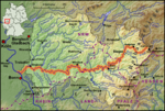
Map of the Lahn river from its source in the Rothaargebirge to its mouth near Koblenz...
18 KB (2,542 words) - 09:06, 15 September 2023

Langenberg (Rothaar) (redirect from Langenberg (Rothaargebirge))
The Langenberg (German pronunciation: [ˈlaŋənˌbɛʁk] ) rises on the state border between North Rhine-Westphalia and Hesse in Germany and, at 843.2 m above sea...
5 KB (543 words) - 20:13, 20 August 2024