The Hochspeyerbach is a 21 km (13 mi) long river in the Palatinate forest in Rhineland-Palatinate and a left tributary of the Speyerbach. The Hochspeyerbach...
4 KB (467 words) - 11:34, 14 December 2020
Woog, reservoir on the Leinbach Franzosenwoog, former reservoir on the Hochspeyerbach Gelterswoog, reservoir of tributaries of the Aschbach Hammerwoog, reservoir...
4 KB (390 words) - 08:44, 22 July 2021

northeast, separating the source region of the Lauter from that of the Hochspeyerbach. The Lauter, which is also called the Waldlauter, flows via the Glan...
4 KB (251 words) - 08:26, 5 January 2019
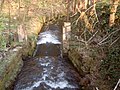
Rhineland-Palatinate, Germany. It was created around 1828 to facilitate timber rafting on the nearby Hochspeyerbach and ceased to exist around 1885. v t e...
1 KB (32 words) - 14:48, 9 October 2020

without dropping below the 450 metre contour line. North of the line from Hochspeyerbach to Speyerbach the highest points are the 570.8 m high Drachenfels and...
90 KB (10,763 words) - 15:12, 13 May 2024

(NHN), it is the highest point of the Palatine Forest north of the Hochspeyerbach - Speyerbach line. The Drachenfels area has been designated as a nature...
6 KB (523 words) - 02:03, 31 December 2021

most important water supplier, the nearly 20-kilometre (12 mi) long Hochspeyerbach, and changes its direction to the southeast. The small town of Lambrecht...
13 KB (1,619 words) - 17:36, 1 June 2021

because line had to pass over the watershed between the Lauter and the Hochspeyerbach between these two towns. This required the construction of a 1347-metre-long...
6 KB (527 words) - 10:09, 5 March 2024

und Eckbach and the southern catchment of the Isenach und Speyerbach (Hochspeyerbach) runs over the Krummes Eck in the west via the Hohe Bühl in the north...
3 KB (349 words) - 09:22, 30 March 2024

west-northwest. The tracks are almost parallel to federal highway 37 and the Hochspeyerbach stream. Directly north of the station is the Gipp Tunnel. The former...
16 KB (1,601 words) - 15:23, 7 July 2022