
The Yarlung Tsangpo, also called Yarlung Zangbo (Tibetan: ཡར་ཀླུངས་གཙང་པོ་, Wylie: yar kLungs gTsang po, ZYPY: Yarlung Zangbo) and Yalu Zangbu River (Chinese:...
13 KB (1,247 words) - 10:56, 22 June 2024

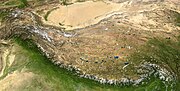
The Yarlung Tsangpo arid steppe ecoregion (WWF ID: PA1022) covers the river valley of the Yarlung Tsangpo River on the southern edge of Tibet. The river...
5 KB (446 words) - 19:35, 9 March 2024

in the gorges of the upper Irrawaddy and Salween rivers. The Yarlung Tsangpo arid steppe lies in the upper Brahmaputra Valley of Tibet, north of the Eastern...
7 KB (575 words) - 15:38, 3 December 2023
Himalayan alpine shrub and meadows Yarlung Tsangpo arid steppe Alashan Plateau semi-desert Eastern Gobi desert steppe Junggar Basin semi-desert Qaidam Basin...
3 KB (344 words) - 12:04, 30 July 2023
the central and northeastern Tibetan Plateau The Yarlung Tsangpo arid steppe in the Yarlung Tsangpo river Valley, where most of the permanent human population...
40 KB (4,803 words) - 06:31, 9 July 2024

drier Central Tibetan Plateau alpine steppe of central Tibet. The Karakoram-West Tibetan Plateau alpine steppe lies to the southwest. Alpine shrublands...
5 KB (499 words) - 07:25, 22 November 2021

west–east direction parallel to the main Himalayan range. Located north of Yarlung Tsangpo river on the southern edge of the Tibetan Plateau, the Transhimalaya...
11 KB (1,011 words) - 11:01, 20 March 2024

correspond to the basin of the Lhasa River, a major tributary of the Yarlung Tsangpo River. It lies on the Lhasa terrane, the last unit of crust to accrete...
115 KB (11,476 words) - 22:31, 1 July 2024

region is about 1,500 km long and 250 km wide, stretching from the Yarlung Tsangpo river valley in Tibet in the southwest, to the Qilian Mountains of...
4 KB (371 words) - 19:34, 9 March 2024

Shigatse Prefecture. China National Highway 219 follows the valley of the Yarlung Tsangpo River some 50 kilometres (31 mi) north of the border. Till today Manang...
99 KB (10,533 words) - 14:10, 9 June 2024