
Domleschg is a municipality in the Viamala Region in the Swiss canton of Graubünden. On 1 January 2015 the former municipalities of Almens, Paspels, Pratval...
14 KB (744 words) - 00:17, 23 March 2024

The Domleschg (Romansh: Tumleastga) is a valley in Graubünden in Switzerland. Geographically, the name "Domleschg" covers both sides of the valley. Politically...
4 KB (447 words) - 14:04, 6 March 2024
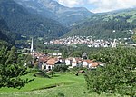
Sils im Domleschg (Romansh: Seglias) is a municipality in the Viamala Region in the Swiss canton of Graubünden. Sils im Domleschg is first mentioned in...
13 KB (1,305 words) - 07:53, 8 May 2024
Mathias (2007). Der Sprachwechsel im Domleschg und am Heinzenberg (19./20. Jahrhundert) [The language change in Domleschg and Heinzenberg (19th/20th century)]...
169 KB (18,222 words) - 14:48, 9 August 2024

The Kreis Domleschg forms, together with the sub-districts of Avers, Rheinwald, Schams and Thusis, the Hinterrhein District of the Canton Graubünden in...
4 KB (152 words) - 16:32, 29 March 2024

north. It flows through the three valleys named Rheinwald, Schams and Domleschg-Heinzenberg. The valleys are separated by the Rofla Gorge and Viamala...
95 KB (10,755 words) - 16:00, 9 August 2024

Chur Churwalden Conters im Prättigau Davos Disentis/Mustér Domat/Ems Domleschg Falera Felsberg Ferrera Fideris Fläsch Flerden Flims Furna Fürstenau Grono...
7 KB (626 words) - 18:00, 1 October 2023

convergence with the Albula, the Posterior Rhine forms a wide valley, the Domleschg, until it meets its anterior counterpart. After that, the Rhine collects...
60 KB (6,444 words) - 22:16, 26 July 2024
Churwalden in the canton of Graubünden. It lies on the range separating the Domleschg from Lenzerheide. Retrieved from the Swisstopo topographic maps. The key...
1 KB (50 words) - 11:23, 3 May 2022

Paspels (category Domleschg)
Paspels, Pratval, Rodels and Tomils merged to form the new municipality of Domleschg. Paspels is first mentioned in 1237 as in villa Pascuals though the original...
9 KB (775 words) - 12:33, 8 May 2024