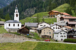
Innerferrera (Romansh: Calantgil) is a village in the district of Hinterrhein in the Swiss canton of Graubünden. Previously an independent municipality...
8 KB (764 words) - 12:37, 8 May 2024
Switzerland. It was formed on 1 January 2008 through the merger of Innerferrera and Ausserferrera. Geographically, it covers the entire Ferrera valley...
6 KB (320 words) - 16:58, 29 May 2024

populated places. The upper village is Innerferrera (Romansh: Calantgil), where the river is dammed, forming the Innerferrera reservoir since 1961. Below Ausserferrera...
4 KB (263 words) - 13:43, 14 June 2024

and is drained by the Avers Rhine. The only villages in the valley are Innerferrera and Ausserferrera. Administratively, the municipality of Ferrera coincides...
2 KB (201 words) - 19:43, 15 November 2023

Por (3,028 m) is a mountain of the Oberhalbstein Alps, located west of Innerferrera in the canton of Graubünden. It is the culminating point of the group...
1 KB (59 words) - 17:47, 16 April 2022

independent municipality before, it merged on January 1, 2008 with neighboring Innerferrera to form the municipality of Ferrera. Ausserferrera is first mentioned...
7 KB (637 words) - 08:05, 8 May 2024

(2,854.5 m) is a mountain of the Oberhalbstein Alps, located east of Innerferrera in the canton of Graubünden. It lies on the chain between the Val Ferrera...
1 KB (59 words) - 03:08, 30 April 2022

path Naret Ticino Ossasco - Fusio 2438 bridle path Niemet Grisons/Italy Innerferrera - Pianazzo 2295 bridle path Panix Glarus/Grisons Elm - Pigniu 2407 bridle...
33 KB (61 words) - 16:07, 25 July 2024

Chiareggio to Maloja. R80: From Maloja to Juf. R81: From Juf to Innerferrera. R82: From Innerferrera to Isola. R83: From Isola to Pian San Giacomo. R84: From...
20 KB (2,612 words) - 05:47, 24 May 2024

masks. In Poschiavo and Mesolcina, formerly also in Scuol, Tschlin and Innerferrera, a straw effigy symbolizing winter is burned. Types of cowbells used:...
4 KB (563 words) - 11:19, 2 May 2023