The Kalmit is the highest peak in the Palatinate Forest and the second highest (after the Donnersberg) in the Palatinate region of Germany. It is 672.6 m above sea...
14 KB (1,693 words) - 00:04, 22 October 2022

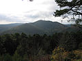
The Kleine Kalmit ("Little Kalmit"; from Lat. calvus mons = bare hill) is a hill, 270.5 m above sea level (NN) high, just outside the eastern edge of the...
4 KB (278 words) - 04:32, 15 May 2023

lies within the Palatinate Forest (Pfälzerwald). Its highest point is the Kalmit, near Maikammer, which stands 673 metres (2,208 ft) above sea level. Dickinson...
1,000 bytes (91 words) - 19:49, 20 August 2024

Felsenmeer on the Kalmit in the Palatine Forest...
7 KB (842 words) - 08:15, 23 September 2023

Weinstraße is a hill, 545.2 m above sea level (NHN), and subpeak of the Kalmit, the highest mountain in the Palatinate Forest. It is part of the Haardt...
4 KB (283 words) - 17:15, 27 March 2020

Naturpark Pfälzerwald) covering 1,771 km2 and its highest elevation is the Kalmit (672.6 m). Together with the northern part of the adjacent Vosges Mountains...
90 KB (10,763 words) - 17:19, 7 September 2024

Rhineland-Palatinate Osterwald Fast 419 1,375 Lower Saxony Palatinate Forest Kalmit 673 2,208 Rhineland-Palatinate Rammert Hohwacht 590 1,940 Baden-Württemberg...
24 KB (142 words) - 11:46, 24 June 2024

Totenkopf. It then makes its way through the Hüttenhohl to the summit of the Kalmit which, at 673 metres, is the highest mountain in the Palatine Forest (with...
28 KB (3,332 words) - 14:21, 7 October 2024

Wildenburger Kopf (674 m), Birkenfeld district, Schwarzwälder Hochwald, Hunsrück Kalmit (673 m), Südliche Weinstraße district, Haardt, Palatine Forest Hohe Wurzel...
19 KB (1,330 words) - 18:35, 14 March 2022

Südliche Weinstraße is a subpeak, 620.1 m above sea level (NN), of the Kalmit (672.6 m) the highest mountain in the Haardt in the eastern Palatinate Forest...
7 KB (630 words) - 11:15, 14 January 2023