
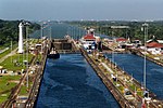
river, canal or lake, is navigable if it is deep, wide and calm enough for a water vessel (e.g. boats) to pass safely. Navigability is also referred to in...
14 KB (1,937 words) - 20:56, 26 July 2024

Navigable aqueducts (sometimes called navigable water bridges) are bridge structures that carry navigable waterway canals over other rivers, valleys,...
8 KB (1,021 words) - 06:54, 18 November 2023
tidewater navigable bay and deposited the dredged materials in a navigable arm of the bay called Mason Creek. The dredging destroyed the navigability of Mason...
27 KB (4,380 words) - 19:50, 18 August 2024

Waterway (redirect from Navigable waterway)
Maritime shipping routes cross oceans and seas, and some lakes, where navigability is assumed, and no engineering is required, except to provide the draft...
6 KB (672 words) - 06:26, 22 July 2024

Channel (geography) (redirect from Navigable channel)
important for the functionality of ports and other bodies of water used for navigability for shipping. Naturally, channels will change their depth and capacity...
11 KB (1,276 words) - 02:29, 6 August 2024

The Hierarchical navigable small world (HNSW) algorithm is a graph-based approximate nearest neighbor search technique used in many vector databases....
5 KB (495 words) - 09:16, 30 July 2024

is thus navigability for commercial purposes, but that is not applicable in the common law provinces. The underlying concept of navigability in law is...
24 KB (2,934 words) - 18:56, 5 August 2024

waterways of the United States include more than 25,000 mi (40,000 km) of navigable waters. Much of the commercially important waterways of the United States...
17 KB (2,226 words) - 18:13, 21 November 2023

2°22′52.2″W / 53.500611°N 2.381167°W / 53.500611; -2.381167 The Worsley Navigable Levels are an extensive series of coal mines in Worsley in the City of...
10 KB (1,192 words) - 20:20, 8 August 2024
Ship canal (section Navigability)
the canal. The standard used in the European Union for classifying the navigability of inland waterways is the European Agreement on Main Inland Waterways...
9 KB (647 words) - 14:10, 15 September 2023