
cartographer John Rocque produced two maps of London and the surrounding area. The better known of these has the full name A Plan of the Cities of London and Westminster...
21 KB (2,135 words) - 12:38, 20 August 2024

related to John Rocque. A detailed biography Rocque's map of London online Rocque's clickable map post-road of Europe Rocque's Exact Survey of Dublin 1756...
8 KB (867 words) - 03:12, 1 July 2024

Great Portland Street (category Streets in the City of Westminster)
authors list (link) John Rocque's Map of London 1741-5, John Rocque, Map of London, 1741-5 Richard Horwood (1795) PLAN of the Cities of LONDON and WESTMINSTER...
33 KB (3,655 words) - 16:03, 21 July 2024
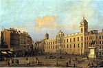
Northumberland House (category Demolished buildings and structures in London)
SP14/109 f.77. John Rocque's Map of London, 1746 Per inscribed tablet at Syon House, see File:Percy Lion plaque.jpg Manolo Guerci, London's Golden Mile:...
11 KB (1,190 words) - 11:41, 4 September 2024
parts of London: Central London, North London, East London and South London. West London was part of the historic county of Middlesex. Early West London had...
14 KB (1,595 words) - 12:24, 19 July 2024
University of Virginia, the British Library, and the UK Hydrographic Office. Some of Rocque's maps were published under the name M. A. Rocque. Rocque was buried...
10 KB (925 words) - 04:31, 6 July 2024
is shown in a series of detailed maps, particularly John Rocque's 1741–45 map (see below) and his 1746 Map of London. New districts such as Mayfair were...
86 KB (10,592 words) - 01:20, 6 September 2024

Burdett. p. 30. Rabbitts 2015, p. 49. Rabbitts 2015, p. 37. John Rocque's Map of London (Map). 1746. Archived from the original on 4 July 2017. Rabbitts...
58 KB (6,063 words) - 22:14, 7 June 2024

Brick Lane (category Streets in the London Borough of Tower Hamlets)
street of the same name), Well Street and Church Street. John Rocque's Map of London, 1746 Map, publisher unknown, dated 1787, showing Spitalfields ("Spittlefields")...
22 KB (2,454 words) - 19:23, 5 September 2024

ran further, along what is now the Man in the Moon Passage. John Rocque's Map of London, 1746 shows Vine Street extending from Piccadilly northeast to...
8 KB (974 words) - 08:01, 7 September 2024