
Eysturoy (Faroese pronunciation: ['ɛstroi], meaning 'East Island') is a region and the second-largest of the Faroe Islands, both in size and population...
7 KB (479 words) - 21:03, 2 October 2023

Eysturoyartunnilin (redirect from Eysturoy Tunnel)
Eysturoyartunnilin (in English The Eysturoy Tunnel, earlier known as Skálafjarðartunnilin) is a large undersea road tunnel under the Tangafjørður sound...
23 KB (2,343 words) - 15:10, 3 April 2024
established between Norðskáli on Eysturoy and Nesvík on Streymoy; in 1976 the new tunnel between Norðskáli and Eysturoy was completed. The Faroes' two largest...
15 KB (1,558 words) - 08:56, 22 May 2024

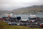
Norðragøta (Danish: Nordregøte), also just referred to as Gøta, is a village on Eysturoy island, Faroe Islands. The municipality of Gøta (Gøtu kommuna) was a municipality...
7 KB (349 words) - 11:42, 27 February 2024

village in Nes Municipality on the southwest coast of the Faroese island of Eysturoy. The 2005 population of the village of Nes was 230. Besides Nes, the two...
6 KB (238 words) - 07:01, 25 July 2024

them in order to keep sheep out. Streymoy is separated from the nearby Eysturoy, the second-largest island of the Faroe Islands, by the sounds of Sundini...
9 KB (816 words) - 10:42, 1 September 2023

under the Leirvíksfjørður in the Faroe Islands. It connects the islands of Eysturoy and Borðoy. The tunnel is 6.2 km long and goes down to a depth of 150 metres...
4 KB (306 words) - 13:47, 30 June 2024

Selvagens Rockall São Tomé and Príncipe Faroe Islands (Denmark) Borðoy, Eysturoy, Fugloy, Hestur, Kalsoy, Koltur, Kunoy, Lítla Dímun, Mykines, Nólsoy, Sandoy...
8 KB (731 words) - 04:05, 3 April 2024

Innan Glyvur is a village on the Faroese island of Eysturoy in the Sjóvar Municipality. It is on the west side of Skálafjørður. It was founded in 1884...
4 KB (59 words) - 15:16, 15 September 2023

at an elevation of 880 metres. It is located in the northern part of Eysturoy, between the villages of Eiði, Gjógv, and Funningur. Funningur lies at...
2 KB (155 words) - 08:27, 26 May 2024