
Olancha (Timbisha: Pakwa' si) is a census designated place in Inyo County of the U.S. state of California. Olancha is located on U.S. Route 395 in California...
13 KB (1,500 words) - 21:40, 28 August 2024

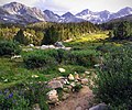
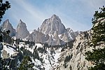
Olancha Peak is a mountain in the Sierra Nevada of California. It rises to an elevation of 12,132 feet (3,698 m) on the Tulare-Inyo county line in the...
3 KB (247 words) - 20:05, 7 July 2023
Bridgeport, Lee Vining, Bishop, Big Pine, Independence, Lone Pine, and Olancha, with Bishop being the largest city in the area. It is sparsely populated...
2 KB (154 words) - 23:07, 30 June 2023

Creek Homewood Canyon-Valley Wells Independence Keeler Laws Lone Pine Mesa Olancha Panamint Springs Pearsonville Round Valley Shoshone Tecopa West Bishop...
11 KB (594 words) - 05:36, 12 July 2024
(105 km) northeast of Bakersfield, and is southwest of Owens Lake and Olancha. Created with the passage of the California Wilderness Act of 1984 by the...
6 KB (503 words) - 00:24, 1 November 2021

in the Sequoia National Forest. The eastern portion begins at US 395 at Olancha, heads east through Death Valley National Park, and ends at State Route...
24 KB (2,820 words) - 06:13, 22 August 2023
the sand dunes and the exterior of the roadside diner was carried out at Olancha, California in the Owens Valley, located on U.S. Route 395, approximately...
7 KB (909 words) - 15:20, 4 October 2024
Retrieved 8 June 2016. "OLANCHA". Datasheet for NGS Station GT1820. U.S. National Geodetic Survey. Retrieved 8 June 2016. "Olancha Peak". Geographic Names...
54 KB (5,512 words) - 01:44, 3 September 2024

Mike Mikesell while they were prospecting for geodes near the town of Olancha, California, it has long been claimed as an example of an out-of-place...
6 KB (707 words) - 11:43, 10 July 2024

Wars. Along the shores of Owens Lake, the highway passes by Cartago and Olancha. Just north of the lake is Lone Pine. Lone Pine is noted as an access for...
56 KB (4,686 words) - 08:00, 15 September 2024