Zervreilasee (redirect from Zervreila)
140 m. The dam is 151 m high and was completed in 1957. The village of Zervreila was flooded after the construction of the dam. A 150-metre-long bridge...
3 KB (183 words) - 23:54, 3 October 2023

the village of Zervreila. Today, the brooks flow into the reservoir, as does the Finsterbach, also from the right. Below the Zervreila dam, the Valser...
2 KB (174 words) - 15:47, 9 April 2023
Harşit River Menzelet Dam 151 m (495 ft) Embankment Turkey Ceyhan River Zervreila Dam 151 m (495 ft) Concrete arch Switzerland River Rhine Porce III Dam...
46 KB (554 words) - 10:38, 22 August 2024

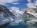
The Guferhorn, or Zervreila, with Zervreilasee at its foot...
9 KB (805 words) - 19:59, 26 August 2024
1960 Göscheneralpsee Curnera Grisons 153 350 Arch 1966 Lai de Curnera Zervreila Grisons 151 504 Arch 1957 Zervreilasee Moiry Valais 148 610 Arch 1958...
5 KB (39 words) - 18:58, 19 April 2024
5% Nant de Drance Switzerland 900 2000 39% Salanfe S.A. Switzerland 70 110 100% Simplon Switzerland 79 238 81,9% Zervreila Switzerland 266 550 21,6%...
30 KB (2,248 words) - 08:25, 10 April 2024
Scharboda is a mountain of the Swiss Lepontine Alps, overlooking the lake of Zervreila in the canton of Graubünden. It lies south of Piz Terri, near the border...
1 KB (57 words) - 23:08, 16 May 2022

and is suspected to be divertet to Lake Zervreila at the level of its dam. A popular hike starts at Zervreila, passes the three remote lakes Guraletschsee...
2 KB (98 words) - 13:00, 23 May 2022

Graubünden. It lies approximately halfway between the lakes of Luzzone and Zervreila. Retrieved from the Swisstopo topographic maps. The key col is located...
1 KB (59 words) - 22:29, 3 May 2022
Graubünden. They lie approximately halfway between the lakes of Luzzone and Zervreila. The main summit has an elevation of 3,043 metres above sea level. Retrieved...
1 KB (71 words) - 22:29, 3 May 2022