
eventually renamed to Landsat 1 in 1975. The most recent, Landsat 9, was launched on 27 September 2021. The instruments on the Landsat satellites have acquired...
41 KB (3,817 words) - 05:15, 6 September 2024
20 satellites. Data provided by non-European satellite missions (e.g. Landsat, GOSAT, Radarsat-2) can also be used by Copernicus. DigitalGlobe, an American...
42 KB (4,701 words) - 05:32, 9 September 2024
November 2004, operational Landsat program Landsat 1, launched July 1972, completed Landsat 2, launched January 1975, completed Landsat 3, launched March 1978...
48 KB (3,943 words) - 19:58, 21 July 2024
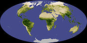
ISBN 9780241418864. GNS Science – Earth's 8th Continent "Antarctica in Context" (PDF). Landsat Image Mosaic Of Antarctica. United States Geological Survey. 3D visualisations...
68 KB (1,346 words) - 17:54, 10 September 2024

to the Landsat program, having designed the Multispectral Scanner which was first used on Landsat 1. She has been called "The Mother of Landsat" for this...
12 KB (1,028 words) - 12:32, 23 May 2024

Sentinel-2 (category Copernicus Programme)
cloud cover and ensuring suitable Sun illumination. It is close to the Landsat local time and matches SPOT's, allowing the combination of Sentinel-2 data...
21 KB (1,886 words) - 09:03, 6 September 2024

Lake Urmia (section Urmia Lake Research Programme)
Iran's Environmental Ticking Bomb Archived 29 November 2011 at the Wayback Machine Landsat - Drying of Lake Urmia, Iran, Google Earth Engine Portal: Iran...
36 KB (3,539 words) - 14:01, 18 August 2024

Venetian Lagoon (category 7 Most Endangered Programme)
Edition (Radio program). NPR. "Venice, Italy (1985–2003) - 25 Years of Landsat 5 - Landsat 5 showcase - Earth Watching". earth.esa.int. Retrieved 1 February...
17 KB (1,535 words) - 00:48, 29 August 2024
Resources Technology Satellite (ERTS), which became the precursor to the Landsat program. These early sensors had minimal spectral resolution, but tended...
27 KB (3,613 words) - 21:40, 15 August 2024
640 km. The payload uses green, red and near infrared bands equivalent to Landsat TM+ bands 2, 3 and 4. Images are stored in a 1-gigabyte solid-state data...
19 KB (2,201 words) - 18:20, 10 September 2024