
Gladenbach Uplands (redirect from Gladenbacher Bergland)
The Gladenbach Uplands (German: Gladenbacher Bergland), named after their central town of Gladenbach, is a range of hills up to 609 m high in the Rhine...
16 KB (1,099 words) - 00:57, 3 April 2024

The right (western) side of the valley is again formed by the Gladenbacher Bergland, from which the Salzböde enters the Lahn. On the left rises the...
35 KB (3,791 words) - 22:22, 4 June 2024

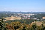
(498m) behind it, right of the center) and others Elevations of the Gladenbacher Bergland (right), 2008 Highest point Elevation 379.4 m (1,245 ft) Geography...
1 KB (38 words) - 00:14, 2 February 2023
BB 1 Website Lahn-Dill-Bergland Hartenrod Eiershäuser Hang Hohensolms Kleingladenbach Sackpfeife Gladenbacher Bergland HE 345–652 6 5 Website Hoherodskopf...
17 KB (86 words) - 17:52, 11 June 2024

Hills (Damshäuser Kuppen, 320.10) belong to the Gladenbach Uplands (Gladenbacher Bergland). The highest mountain in this area is the Nimerich (533 m above...
31 KB (3,206 words) - 17:01, 23 June 2024
Rheinland-Pfalz) BfN-Landschaftssteckbriefe: 320 Gladenbacher Bergland 320.0 Lahn-Dill-Bergland 320.1-2 Gladenbacher Hügelland und Oberes Lahntal 321 Dilltal...
6 KB (531 words) - 19:27, 3 December 2023
Gladenbach lies on the eastern edge of the Westerwald in the Hessian Highland (Bergland). This part of the Lahn-Dill Highland is often also called the Gladenbach...
11 KB (978 words) - 15:16, 20 August 2024