
Caraz, Carás or Caraz de Santa Cruz is a mountain in the Cordillera Blanca in the Andes of Peru, about 6,025 metres (19,767 ft) high. It is located in...
5 KB (319 words) - 05:21, 15 April 2022
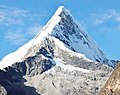
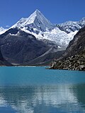
Artesonraju is a pyramidal mountain peak located near the city of Caraz in the Cordillera Blanca mountain range in the Peruvian Andes. It is located at...
9 KB (888 words) - 11:19, 20 June 2024
Pirámide (mountain) (redirect from Nevado Pirámide de Garcilaso)
Province, Caraz District as well as in the Yungay Province, Yanama District. Pirámide lies inside Huascarán National Park, southeast of Caraz and Artesonraju...
4 KB (414 words) - 22:16, 15 April 2022

Beautiful Mountain in the World". Most popular routes start from the village of Caraz, on the north of the Cordillera Blanca. A French-Belgian expedition including...
6 KB (469 words) - 15:44, 3 October 2023

Santa Cruz (mountain) (redirect from Nevado Santa Cruz)
although other maps cite a height of 6,241 metres (20,476 ft). Lake Atuncocha Caraz Taulliraju Ricker, John (1977). Yuraq Janka: A Guide to the Peruvian Andes...
3 KB (173 words) - 01:53, 16 April 2022

Sentilo (redirect from Nevado Sentilo)
Creek originates near Sentilo. Lake Jatuncocha Lake Ichiccocha Quitaraju Caraz (mountain) summitpost.org "Sentilo" Jill Neate, Mountaineering in the Andes...
3 KB (154 words) - 01:54, 16 April 2022
landslide in 1970 that buried the town and killed over 20,000 people) and Caraz which is considered the last city in the valley. The Callejón de Huaylas...
15 KB (2,380 words) - 06:54, 8 August 2022
de Atacama 27°06′S 68°52′W / 27.100°S 68.867°W / -27.100; -68.867 (Nevado Tres Cruces) Argentina – Chile 6,739 Llullaillaco Puna de Atacama 24°43′10...
61 KB (174 words) - 21:34, 18 April 2024

speeds up to 35 km/h (22 mph), causing damage all along the river banks. In Caraz, 11 km (6.8 mi) downstream of Yungay, the airport and much of the surrounding...
33 KB (4,109 words) - 16:10, 12 July 2024

to the Dominance System and its dominance is 46.11%. Its parent peak is Nevado Santa Cruz and the Topographic isolation is 4.9 kilometers. Quitaraju was...
5 KB (330 words) - 14:37, 6 March 2024