entrance. To better mark Aransas Pass, a new light was established in 1952 at the Port Aransas Coast Guard Station, and the Aransas Pass Lighthouse was deactivated...
38 KB (4,278 words) - 22:06, 16 October 2024

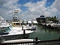
Aransas Pass (/əˈrænzəs/ ə-RAN-zəs) is a city in Aransas, Nueces, and San Patricio counties in Texas, United States. The population was 8,011 at the 2021...
13 KB (943 words) - 22:29, 27 September 2024

northern end of the island is Port Aransas, beyond which is San José Island. The Aransas Channel, also known as the "Aransas Pass," which separates Mustang...
5 KB (547 words) - 04:09, 23 August 2023

San José Island (Texas) (category Landforms of Aransas County, Texas)
confused with the City of Aransas Pass which is on the mainland), beyond which is Mustang Island and the town of Port Aransas. Aransas Pass is protected by...
5 KB (427 words) - 20:35, 29 March 2023

Aransas Pass is a navigable salt water channel connecting the Gulf of Mexico with Aransas Bay on the Texas Gulf coast in the United States. The pass separates...
2 KB (228 words) - 08:09, 30 December 2022
extends into Aransas County. Within Nueces County the district includes Port Aransas and sections of Aransas Pass and Corpus Christi. In Aransas County it...
3 KB (271 words) - 16:01, 22 August 2022
Copano Bay in Aransas County The Aransas Bay, fed by Copano Bay Aransas Pass, Texas, which borders the Aransas Bay Port Aransas, Texas The Aransas Pass, a navigable...
882 bytes (125 words) - 15:22, 22 April 2021

miles (240 km) south of Brownsville. Damage is reported as far north as Port Aransas. Tides rise to 4 feet (1,200 mm) at Padre Island. Sections of highway...
35 KB (3,455 words) - 02:12, 25 July 2024

Island). Aransas Pass is the most direct navigable outlet into the Gulf of Mexico from the bay. The cities of Aransas Pass and Port Aransas are located...
18 KB (1,831 words) - 01:58, 6 September 2023

175 mph (282 km/h) in Port Lavaca, 160 mph (260 km/h) in Matagorda, and 150 mph (240 km/h) in Aransas Pass, Austwell, Edna, Port Aransas, and Victoria. Carla...
38 KB (4,367 words) - 22:30, 9 October 2024