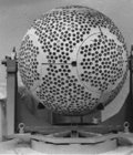
Etalon-1 and Etalon-2 are geodetic satellites. They are designed to determine, with high accuracy, terrestrial reference frame and Earth rotation parameters...
2 KB (75 words) - 23:40, 5 October 2023

benchmark for geodynamical studies of the Earth Etalon (satellite) Satellite laser ranging "Satellite Starshine-3". NASA. Archived from the original on...
5 KB (419 words) - 18:19, 28 May 2024

dedicated laser ranging satellites were put in orbit: Ajisai (Experimental Geodetic Payload) BLITS Calsphere satellites Etalon Kosmos 1989 Kosmos 2024...
4 KB (669 words) - 23:07, 11 March 2024
Satellite geodesy is geodesy by means of artificial satellites—the measurement of the form and dimensions of Earth, the location of objects on its surface...
21 KB (2,338 words) - 20:20, 13 April 2024
dedicated laser ranging satellites were put in orbit: Ajisai (Experimental Geodetic Payload) BLITS Calsphere satellites Etalon Kosmos 1989 Kosmos 2024...
20 KB (1,994 words) - 20:35, 6 July 2024
GLONASS (redirect from Glonass (satellite))
on two launches, an Etalon geodetic reflector satellite was substituted for a GLONASS satellite. The second generation of satellites, known as Glonass-M...
72 KB (6,218 words) - 20:58, 25 May 2024

The Upper Atmosphere Research Satellite (UARS) was a NASA-operated orbital observatory whose mission was to study the Earth's atmosphere, particularly...
24 KB (2,440 words) - 15:00, 22 December 2023

arm is replaced with a Gires–Tournois etalon. The highly dispersed wave reflected by the Gires–Tournois etalon interferes with the original wave as reflected...
36 KB (4,357 words) - 17:10, 9 June 2024
ADM-Aeolus (redirect from Aeolus satellite)
CCD; the etalon was split into two zones, which are imaged separately on the detector. The lidar was aimed 35° from nadir and 90° to the satellite track...
20 KB (1,892 words) - 21:39, 25 April 2024
1994. Its primary instruments were the Hyperspectral Imager, the Linear Etalon Imaging Spectral Array and the Ultraviolet Cosmic Background experiment...
6 KB (448 words) - 13:25, 21 March 2022