
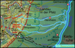
The Hohe Derst is a hill, 561 metres above sea level, in the Palatine Forest of southwest Germany. It lies within the Wasgau region and is the highest...
3 KB (229 words) - 05:34, 29 August 2018

Nothweiler, followed by the Hohe Derst (560.5 m) west of Bad Bergzabern and the Großer Eyberg (513.0 m) southwest of Dahn. The Hohe List (475.8 m) and Erlenkopf...
90 KB (10,763 words) - 17:19, 7 September 2024

503-metre-high Schlossberg hill. One kilometre away are the Hohe Derst (561 m) to the northwest and Hohe Kopf (497 m) to the south. The Otterbach, a left tributary...
6 KB (640 words) - 09:19, 22 December 2022
about 300 metres on the hillside east of Guttenberg Castle between the Hohe Derst (561 m high, to the north) and the Hoher Kopf (497 m high, to the south)...
4 KB (330 words) - 11:38, 14 December 2020

town Wissembourg. Its highest point, at 561 metres (1,841 ft), is the Hohe Derst near the hamlet of Reisdorf. The area includes the remains of Guttenberg...
12 KB (1,481 words) - 21:21, 24 March 2023

Schlossberg (Hohenburg) (Wasgau Felsenland): view from the Wegelnburg Hohe Derst (eastern Wasgau): view from the Stäffelsberg The Hohenberg (eastern Wasgau):...
38 KB (4,236 words) - 17:21, 7 September 2024