
The Kermeter is an upland region, up to 527.8 m above sea level (NN), which is part of the Rureifel within the North Eifel in the districts of Aachen,...
6 KB (745 words) - 05:24, 15 September 2021

from the Kermeter flowing from the south, discharges near the dam wall in the northeastern part of the reservoir Eschbach (1 km); from the Kermeter flowing...
14 KB (462 words) - 07:06, 14 May 2024
forest with a high percentage of beech woods is the region known as the Kermeter. This forested area is accessible and offers a large number of interesting...
14 KB (1,786 words) - 12:13, 25 July 2023

in the Hollerscheid; 120 m northwest of the B 258 527.8 m: in the Kermeter; near the southern edge of Wolfgarten 434.1 m: in the Moselle Hills;...
83 KB (8,205 words) - 08:08, 20 August 2024

Heimbach, in the district of Düren in the Eifel, in the forests around Kermeter, North Rhine-Westphalia, Germany. In September 2018, the last remaining...
10 KB (913 words) - 06:08, 27 April 2024

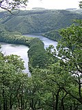
Urftsee lake, which separates the Dreiborn Plateau from the ridge of the Kermeter to the north. The plateau is bisected in an east to west direction by the...
7 KB (945 words) - 00:53, 14 October 2024

Rhine-Westphalia. The village has a population of about 195. Wolfgarten lies in the Kermeter, a hill ridge in the North Eifel within the Eifel National Park. Among...
3 KB (305 words) - 11:37, 24 September 2021

in the Rur Eifel, a subdivision of the North Eifel region, south of the Kermeter ridge, north-northeast of the Dreiborn Plateau between Simmerath-Rurberg...
14 KB (991 words) - 05:15, 16 April 2024
are: Eifel National Park, Monschau Hedegerow Country (Monschauer Heckenland), Kermeter, Hürtgen Forest and Zitter Forest. Hohes Venn - Eifel Nature Park...
1,014 bytes (117 words) - 16:21, 20 April 2020

name of the village (Mund = [river] mouth). On the southern slopes of the Kermeter upland forest and east of the Dreiborn Plateau, the village of Gemünd is...
4 KB (382 words) - 10:05, 16 September 2021